The Best Prepper Phone

Anyone who’s alive pretty much has, or uses a mobile phone today, including toddlers. But have you thought about the prospects of using your mobile phone as a tool in a survival situation and how it would work?

That’s what this post aims to look at, to see whether your current device is up to the task of serving your off-grid needs, completely devoid of an internet connection ever again. Most people haven’t thought about what exactly on their mobile would break in the event the internet was switched off. You may be surprised to find out that as time ticks by without it, more and more features of the phone would cease to operate. One example is Google Maps.

Did you know that even if you downloaded ‘offline’ maps in Google Maps, that they will only work for 30 days? Without internet they will work perfectly fine right up until they day the maps expire, but when that happens Google Maps will simply stop working and you may end up lost in unfamiliar territory – not the best start to the apocalypse.

I have cataloged multiple options below for choosing the most optimal offline device(s) for the collapse, assuming there’s no EMP. You would typically want more than one device with the exact same data in case one of them fails as well and perhaps another of a different variety to make watching content or reading eBooks easier.

This guide is written with the assumption that you want a smart phone rather than a old-school Nokia brick or something similar, since you would likely want apps which can support your prepping rather than just a ‘phone’.


Device Type
To choose the best device that suits your needs first you need to decide on a type of device:

● Phone: These are jack of all trade devices which provide a good medium between functionality, entertainment and portability. They are generally pretty frustrating to read e-books on and aren’t the best at watching video content either, but the small package means it’s lightweight and easy to transport. Today, a phone is pretty much an essential part of your Every Day Carry (EDC) kit since we all probably carry one everywhere we go anyway.

● Note Devices: Larger smartphone devices which often come with a pen for note-taking. They are generally 6-8 inches in size which also accommodates space to insert the pen into the device.

● Tablet: A larger device which is usually focused more on entertainment rather than functionality – such as phone calls. This device would be great to watch and store prepper related videos on as well as reading e-books and yes, watching movies on as well. Tablets can be pretty light and therefore one could make it into your Bug Out Bag or INCH Bag without too much weight gain – although I would recommend the next device for that instead…

● E-Ink E-Reader: These are similar to tablets but use a screen which can hold an image on it without using any battery which makes them amazing for reading e-books and PDFs during a Bug-Out situation. This is what you want if you are going to be reading documents and other informative e-books often as it will use the battery at a MUCH slower rate to a tablet.

Be sure to buy the Linux based devices rather than the Android ones as they retain batter for longer periods. An added bonus is that they are generally lighter than tablets and are more durable too. They can also be used for drawing and sketching which may come in handy, but is no substitute for a pen an paper, because at some point you will run out of power.

● Laptop: This is probably a bit too large and heavy to use as a prepping device, but someone may find a use for a powerful device and large screen such as this. This is a tool better stored in a Bug-Out location in an EMP proof cage than being carried on you.

My choices: Personally, I have a few Samsung S10+ phones (my primary preparedness devices) with one in an EMP proof bag, a Samsung S5e tablet for watching videos, playing games and reading ebooks and I’m looking at buying an E-Ink device for the long term reading of educational eBooks if electricity is scarce. I also have a laptop as my ‘prepper hub’ to sync the files between all the devices and to be able to much more easily type blogs such as this. It’s alsos also used to flash firmware to the portable devices as the other devices aren’t capable of this.

Remember that your usage patterns of the device will vastly change during an emergency. You probably currently spend some time on social medias and chatting to friends on various platforms. However when SHTF, you will pretty much only be looking at maps, reading preparedness manuals and books and watching saved prepper content, with the occasional game if you are stressed. Due to this, don’t choose a device with the best online capabilities or 50 fancy cameras, but instead focus on the aspects you really will need in your personal situation.


Hardware
Before we start looking at actual devices, we need to consider what features it should possess. Have a look at my list below on what I wanted in my prepper phone, and then start your own list rating them on how important they are to you. Have a look here if you want some more ideas of common features on modern smartphones.

● Screen: Generally the device type you choose above will dictate the screen size you have, although you still have a bit of leeway up or down. Pick a size that suits what you will be doing the most of. Remember that higher density is not always better as it will drain the battery faster – even if you set it to display at a lower resolution. e-Readers should have as high a screen resolution as possible since they update the screen infrequently it won’t make much of a difference to the battery life, but you will also be able to read text much more clearly.
My choice: About a 6.4 inch screen at 1080p or 1440p.

● Repairable: How easily can the device be opened and repaired or maintained if a component in it breaks? Also how readily available are parts for it? Have a look on iFixit.com to see scores on how easily a specific device is to repair. If it’s complex, you may want to practice and open it before a disaster hits so you know you can do it without damaging any components – such as the fragile screen.
My choice: The iFixit score doesn’t matter to me much as I’m quite adept at repairing technology.

● Battery: You are going to want a decent battery in any modern device so it can last as long as possible. This is also one of the primary components you will want backups of when the original fails. Ideally you want a removable battery, but most phones today don’t give you that option.
My choice: My S10+ has a 4000mah battery and I have 2 spares. I also have an ifixit kit to open the phone to do the battery replacement.

● Phone Status: Locked/Unlocked
My choice: This won’t matter in a grid-down situation, but for now I prefer to have it carrier unlocked so I can use any network SIMs in it. When the grid does go down, I will be removing the SIM anyway.

● Camera: Wide, Telephoto, Ultrawide etc.
My choice: I don’t mind what camera a phone has, as long as it has a single one on the back. If it has a front camera, I don’t want it using up screen real estate. (One of my main annoyances with my S10+)

● Storage: You want to look for the biggest storage space possible to keep all the files you’ll end up saving to the device. Generally people regret not going up in size, rarely do they say they wish they bought the smaller model, plus when you start loading up the storage with prepper videos, maps, books and entertainment you will find it runs out pretty quickly.
My choice: For my S10+, I look for a 512Gb or 1TB phone.

● Micro SD Slot: In my opinion, this is an essential feature for any preparedness phone I’m looking for, since I can plug in a 1TB MicroSD card and instantly have a huge volume of space to do whatever I need.
My choice: Absolutely need this. I also have an array of MicroSD cards full of different prepper content which I can plug in and transition between at ease.

● Port Type: Do you want a USB-C, Micro USB, Mini USB or another type of charging jack?
My choice: Type-C port since I can also plug in my 1TB T1 Samsung portable SSDs into my phone to access a huge array of prepper videos if required. With all the above storage plugged into my phone, this essentially brings the total storage space up to 2.5Tb (512Gb Phone, 1TB MicroSD, 1TB USB-C SSD) – more than enough…. for now.

● 3.5mm Audio Jack: Used to plug old-school headphones or earbuds into.
My choice: I like to have this if possible to avoid wireless devices when in the field which could give away my position. The audio jack is often used as an antenna by wired earphones for the on-board radio in some devices – so if it doesn’t have the audio jack, it most likely doesn’t have radio capabilities.

● Loudspeaker: This may be useful if you want to play wildlife calls to attract animals, otherwise you are likely never going to need a loudspeaker and it may be wise to physically disconnect it from the motherboard to avoid accidentally playing music and giving away your location.

● Network Type: 3G / 4G / 5G
My choice: I avoid 5G phones, so I stick with older models of Samsung phones before 2020. The older phones also have better compatibility with custom roms due to being tried and tested over the years.

● Sensors: Fingerprint, accelerometer, gyro, proximity, compass, barometer, heart rate, SpO2 etc.
My choice: I just look for the compass and barometer primarily, the rest generally just come with every device today.

● Positioning: GPS, GLONASS, BDS, GALILEO, QZSS etc.
My choice: I try to get all of the above to make it easier to find my position in offline apps. Most devices today come with at least one type of positioning, however be sure to check the specs on as older tablets may not have any.

● Charging: Cable, Wireless (Qi), Reverse Wireless, Fast Charging
My choice: Grid-up, my choice is to use wireless charging to save the USB-C port (since each time you plug in the cable, it gets ever so slightly damaged until the port eventually fails and you have to hold the cable at a particular angle to get it to charge). Grid-down I will use cable charging as wireless charging is inefficient due to some power being lost during transmission.

● Flip Devices: As a prepping device, you want to avoid anything that can cause your device to break prematurely, and a big cause of failure is any device that can fold. This technology is still relatively new and over time the folding mechanisms have been known to fail, either partially or catastrophically. Even though your screen is more protected when flipped shut, you don’t want water somehow seeping into the seam and causing the entire device to stop working. The less points of failure you have – the better.
My choice: Avoid flip & folding devices.

● Waterproofing: Ideally you will want your device to be usable in heavy rain and also be submersible in water up to a meter or two (in case you drop it into a river). Look for an IP67 or IP68 rating when choosing a phone.
My choice: Look for an IP68 device.

● Toughness: Finally consider the toughness of the phone. Will it easily break if dropped? Are you the kind of person who drops their phone often? I’m EXTREMELY protective of my phone and always ensure I put it fully on a flat surface, double check it’s in my pocket before exiting the car (since I hopped out of the car with it on my lap once – RIP S7 Edge) and I don’t carry anything else in my pocket when the phone is in there to prevent it getting scratched by keys etc. Even then, I have cracked 2 phones, so either choose a tough device that can handle the stress of a SHTF world, or carry backups and spare parts.
My choice: Being highly ‘precious’ with my phone, I opted for a device with a large screen and curved edges, but also have backups of the same phone as well.

Have a think about any additional features you would like your prepper phone to have and add to the list above. Consider whether they should be essential, useful or nice-to-have features.


Device Manufacturer
Next you want to look at the which manufacturer you would like to go with which has all the features you listed above. At the same time, you also want to have in mind the next step, which is the operating system you want to use.

● Samsung Devices: Cutting edge devices that generally have it all. A couple of things to gripe about such as the recent removal of the MicroSD card slots and the 3.5mm ports from their newest generation phones (from 2010 onwards). Some models have ugly camera cutouts as well, such as the S10+. Samsung phones are not easy to repair yourself and generally don’t have user replaceable batteries. (LOS – Lineage OS & EOS – eFoundation Compatible)

● Google Devices: The hardware of the Google devices is highly secure, but we want to avoid big tech companies operating systems running on top of that. If you choose a Google device, make sure you flash a new OS onto it such as Graphene – if not, try to avoid Google devices. Also google have dropped a lot of the best prepper related hardware such as the MicroSD slot and the 3.5mm audio jack. (LOS, EOS, Graphene Compatible)

● Apple Devices: Avoid! You can’t install custom ROMs on iPhones so you’re stuck with the apple iOS which is terrible for a number of reasons listed in the section below.

● Sony Devices: Generally pretty nice devices. (LOS & EOS Compatible)

● LG Devices: A little lackluster in the ‘wow’ department like Samsung phones, but LG’s phones are generally pretty rugged and have the features I need such as a MicroSD card slot. (LOS & EOS Compatible)

● ASUS Devices: Another decent phone manufacturer which has some pretty cutting edge features on their devices such as pop-up cameras. (LOS & EOS Compatible)

● Fairphone Devices: A very privacy focused company. Some of their phones are a bit plain but they work. (EOS & LOS Compatible)

● Motorola Devices: (LOS & EOS Compatible)

● Xiaomi Devices: (LOS & EOS Compatible)

My choice: I went with a Samsung device as I’m already familiar with their operating systems and there is such a huge range of phones to choose from I could get nearly exactly what I was looking for in a phone. Also due to their ubiquitous nature modding flagship phones is fairly straightforward. If you need help choosing a company to go with, first decide what operating system you prefer and look up their website to see what phones their OS currently supports.


Operating System
Android
This is probably the most ubiquitous operating system out there, but there are so many variants of it that you have to look deeply into what features it provides and what ‘bloatware’ the manufacturer has installed. Different manufacturers also have varying policies on tracking their users, such as Google and Samsung which you may want to look into.

iOS (Apple)
I would avoid apple products AT ALL COSTS due to their closed source, non-privacy friendly behaviour. There’s so much more, so I’ll summarize it quickly: They have a culture of cloud storage and synced devices. Devices have limited storage space – compared with other devices with expandable storage. Very difficult/impossible to sideload content. They gather and store information on their users. You can get ‘locked’ into the iOS environment. Their devices are essentially ‘glued’ to the internet. You can’t customize or expand the storage space. There are no audio ports anymore. The software is locked down. It’s difficult and also fairly pointless to jailbreak.

Lineage OS (LOS)
A deGoogled operating system for a variety of phones and tablets. It’s a powerful and privacy focuses OS and can be greatly customized and also features a very large user base. The code is open source so there’s less likely to be shifty things going on under the hood.

EOS (E Foundation)
Another deGoogled operating system for a larger selection of phones and tablets than the above. EOS is a little more user friendly than Lineage OS for those starting out. It’s also open source with their mantra being “Your data is YOUR Data”.

● Others (Graphene, Ubuntu, Ubuntu Touch, CalyxOS, POP! OS)
Feel free to look into using any other operating systems which take your fancy. Ubuntu and POP! OS are operating systems for laptops if you’re going down that route.

My choice: I went with EOS for its privacy friendly and open source nature. I also have files to be able to flash Lineage OS onto my phone at any point in the future without needing the internet. Both of them are pretty much the same, but EOS is slightly more user friendly and Lineage is slightly more secure.


Superuser
There is a degree of skill required to build a prepping phone from scratch due to the need to flash a new operating system (OS) onto the device and the requirement to root it – which if you do either of them wrong can ‘brick’ the device and cause it to be unusable. Don’t worry though, I’ve made some mistakes flashing my device and there always seems to be a way to recover from it.

If you don’t want to go down this route, or don’t feel that you have the skills to do this you can always stick with the original OS and not modify anything – just be sure that you will be more vulnerable if there was ever a cyber hack or the ‘powers that be’ decide they want to track your phone. Below are the four different levels of manipulations which you can modify your phone.

● Stock OS – No Root: This is the default operating system that comes with the phone without root privileges. Most people have this setup by default. There is nothing you need to do to achieve this as phones just come ‘stock’.

● Rooted Stock OS: The default OS with root privileges. This gives you superuser access and allows you to modify pretty much whatever you want. At the very least I recommend rooting your stock operating system to gain the ability to perform superuser functions like backing up and restoring apps.

● Custom OS – No Root: The existing operating system has been replaced with a new one, but the phone is not rooted. This is a pretty rate occurrence as rooting can easily occur during the installation of a custom OS.

● Rooted Custom OS: In my opinion this is the best setup for privacy and the ability to modify your phone to suit your needs. It requires some skill to do and the process is different for each device, but generally there are complete guides to follow online for most of them – at least for the most popular phone models. There’s really only a few more steps to this over the step above, so you might as well go the full way if you’re modifying your phone.


Apps & Software
Finally we get to the apps & software you want to use on the device and whether it’s worth choosing one device over another for certain features.

For a list of preparedness apps I use on my device including links to download them, have a look at my blog post on The Best Prepper Apps to Download.


User Recommendations
To make device selection easier, I have included a list of recommended prepper phones that have been suggested by notable figures on the web.

Modern Smartphone Pick: Samsung Galaxy S10/S10+
This phone is a modern all-rounder, featuring the latest technologies (for its time) such as a nice screen, microSD card slot, 3.5mm audio jack, wireless charging, a radio (in USA/Canada), no 5G and more.
Although I use the S10+ model, really any Samsung phones around the 2019 era have a great array of useful features needed for prepping. Have a look at the S8+, S9+ as well, as they are all similar with slightly different designs, features and batter sizes, so you will probably find one that suits your needs. The S8/S8+ is smaller and much lighter phone to the S10 if that interests you.

Even though I have (and use) the S10+ model, I find it frustrating having a large cutout on the screen taking up screen real estate. The only different between the S10 and S10+ is the size of the screen, the battery size and the Ram – out of which I only really care about the battery.

The negatives of my S10+ is the screen cutout – I wish there was just a small circle, or nothing at all. Also the non-user replaceable battery is frustrating as there’s quite a lot of steps opening the phone before you get to the actual battery. Finally, I would have liked an FM radio in mine.

A point to note – only the Exynos model of the S10 can have the operating system modified, so be sure to look into flashing your own OS before committing to any phone if that’s a route you want to go down. I would read through the flashing guide in its entirety to see if there’s anything you have missed, such as the software only working on a particular model of a phone or whether there’s any known bugs.

Cheap Smartphone Pick: LG G4 (Canadian Prepper Recommended)
This 5.5 inch phone features a user replaceable battery, a microSDXC slot, a decent 1440×2560 screen, a 3.5mm audio jack and an FM Radio which is rare on phones. Downsides are that there’s only 32Gb internal memory, only 3000mah battery, it has a microUSB port and the phone is now discontinued so it may be hard obtaining one. This is a fairly old recommendation so there are likely to be better models now which have more modern hardware.

Ultra-Privacy Centered Pick: Librem 5
This unique phone has 3 kill switches on the side to physically disconnect the 1. WiFi/Bluetooth, 2. Cellular Networks, and 3. Microphone and Camera for maximum privacy. Each switch will also disable the GPS when flicked as well, which may not be ideal if you are trying to navigate while ‘stealthed’. It also has a user replaceable battery and a microSD card slot. It has a low resolution screen coming in at 720×1440, it doesn’t have an FM radio and it costs $999+ USD.

Best Privacy & Security Pick: Google Pixel 5/6/7/8
A Google Pixel phone running GrapheneOS is arguably the best private and secure smartphone. Even though Google as a company is highly dubious regarding user privacy, the security hardware on the Pixel phones is unmatched. Additionally, Google makes it easy to install your own operating systems onto their phones which removes a layer of stress which usually comes with flashing a phone like the Samsung S10+ with its many layers of security to try to deter you. Unfortunately Pixels don’t come with a MicroSD card slot or a 3.5mm audio jack.

FOSS Pick (Free Open Source Software): Pinephone and Pinephone Pro
These neat little 6″ 1440×720 phones are a blend of open source software and privacy focused hardware. They have physical buttons which allow you to disable the cameras, microphone, WiFi, Bluetooth, and the mobile connection at will. It’s fully repairable and therefore allows easy access to the hardware modules including the battery. They have MicroSD card slots supporting up to 2TB – which will help you store all those prepper videos, maps and eBooks you’ll need.

Ultra Tough Pick: Unihertz Tank
This ultra-rugged phone will withstand even the harshest elements. It has a 22,000mah battery inside which is about 5.5x larger than the average smartphone battery. It has a 3.5mm audio jack and an FM radio which is nice to see. As for negatives, it weights a hefty 560g, the battery isn’t removable and there’s no MicroSD card.

Tactical Pick: Ulefone Power Armor 19T
A phone with built-in FLIR thermal imaging, a hefty 9,600mah battery, microSD card slot, IP68 & IP69K waterproofing, a 120hz screen and 180MP camera.

That’s it, if you have any questions please leave a comment. Otherwise check out some of my other digital prepping related blogs below:

The Best Prepper Apps to Download
Offline YouTube Prepper Archive – How To
Offline Preparedness Maps – An Introductory Guide

Offline YouTube Prepper Archive – How To

As preppers, knowledge can be the biggest asset in a grid-down situation. It can allow you to ‘loan’ skills and ascertain quicker results than if we attempted to try things ourselves without any prior knowledge. One of these biggest hubs of knowledge right now is the video streaming website YouTube. I’m sure most of you visit daily and learn from some of the greats including Southern Prepper 1, Sensible Prepper, The Provident Prepper, City Prepping and Canadian Prepper.

However these essential resources aren’t much use if the internet goes down. We need a way to store this information for use in a grid-down situation when we need it most. Below I will dive into how you can download videos to create an ‘Offline Prepper Video Archive’.

I’m going to go ahead and predict that preparedness content won’t be readily available for too much longer due to a range of storms heading our way, including:
● The internet won’t last long in any major conflict, and we seem to be on the verge of a world war.
● Hacking and ransomware has become much more common which could easily take out the internet in an entire country.
● Big Tech companies are actively silencing those who don’t agree with their agenda, and that includes Preppers.
● YouTube is taking steps to block third party downloaders like those mentioned below.
● Prepping is anti-mainstream and Governments certainly don’t want their populations to be self-reliant as this means less income for them.
● Infrastructure is aging worldwide and isn’t being maintained to the standards it should be, this includes electrical grids and internet networks.
● World Governments are actively censoring information and filtering it for their advantage – such as what currently occurs in China, Iran, North Korea and more.

Whatever the reason you want to download preparedness videos, there are a couple ways to achieve it. This list is by no means conclusive, as there are probably hundreds of different programs and websites that can download YouTube videos.


Download Videos on a Phone Using an App (NewPipe) (Single Videos Only, Easy to Use)
An easy way to download single videos is by using NewPipe. Just download and install the app and then search for a video you want to download and hit that download button. Then you just have to choose your settings like the quality of the video and whether you want the whole video or you just want to extract the audio from it.


Download Videos Using 4K Video Downloader (Paid) (Bulk Downloads, Easy to Use)
This is by far the simplest way to download a huge amount of videos at once and it doesn’t require lots of setting up like JDownloader or Stacher below. All you have to do is paste anything from links to playlists by using the “Paste Link” button at the top and it will download each video in a playlist, one at a time – or even multiple at a time based on your settings. (Just don’t download them too quickly or YouTube will block your IP address and then you won’t be able to download or watch any videos!)

If you close the window 4K will resume where you left off which is an extremely handy feature so you don’t lose track of where you’re up to and what’s been downloaded so far. The only issue I’ve found is that the video can sometimes fail to download correctly and ends up being unplayable. If this happens all I have to do is delete the unfinished file and copy and paste the link again. The title “4K Video Downloader” is a bit of a misnomer, since you can select any resolution you want to download in and not just 4K.


Download Videos Using JDownloader (Free) (Bulk Downloads, Precise Download Control, Complex)
JDownloader requires FFMPEG to be installed, but it can do this automatically with a connection to the internet.

To get started with JDownloader (called JD from here on), firstly install the software and then proceed with the FFMPEG installation which will pop up automatically if it’s not already installed. Make sure JD is running and then head over to YouTube and copy the link to any video you want to download. Swap back to JD and you should see that it has automatically parsed the link you copied and populated the “LinkGrabber” tab up the top with a bunch of different files if you click the “+” to the left. You don’t need most of these, so before we go further we’re going to change some settings.

Head to ‘Settings’ and you should see the ‘Plugins’ section up the top. Click in the “Please choose a plugin” area and remove whatever’s there, and start to type “YouTube” – clicking it when it shows up. When selected you will see a LOT of different options available to you which may seem daunting, but to keep it simple I will let you know my settings and you can work from there.

Under “Allowed Media Types”:
(Just un-tick all the other options until only the below options remain)
● Type: Audio, Video
● Filetype: MP4
● 3D/360: 2D
● Image/Video Resolution: 480p (Or whatever your quality preference is)
● Fps: 60, 50, 30, 24

Go to “Settings” > “Settings” > “General” and at the very top you can set the folder where the downloads will be saved. It’s best to create a new folder called “JDownloader” in a drive which has a good amount of space. (at least 10+ Gigabytes)

Once you’ve done that, head back to the “LinkGrabber” tab and delete the top row that has the box icon to the left of it by right-clicking it and going ‘Delete’. Then re-copy the YouTube link you copied before and let it parse it. (If you’ve disabled the automatic link parsing, you can manually scan links with the “Add New Links” button in the bottom left. You should hopefully now only see one file available to download if the link you copied wasn’t a playlist. If you’re happy with the selection scheduled for download, you can press the blue download button on the far top left side under “File”. Then just sit back and let the files download.

Once it reaches 100% it’s downloaded and you can right click the video file and choose “Open Download Directory” to open the folder where you saved it. If you want you can also double click the file to play it from JD.

If you encounter any issues with the download, you should try updating to the latest JD version as YouTube often patches their website which breaks the download capabilities of most downloaders. If you still have issues you could search for the issue you are having in a search engine.


Download Videos Using Stacher (Free) (Bulk Downloads, Imprecise Control)
Stacher is a free program used to download YouTube videos and playlists. It requires FFMPEG like JDownloader above but unfortunately you have to install it manually this time. Just head to the link above and download the executable for your operating system. To install it, follow the process here or the steps below.

FFMPEG Installation:

Windows
Download the latest binaries from the yt-dlp maintained repo.
Once downloaded, in Stacher click the ‘Tools’ menu and select the Import ffmpeg *.zip option.
A dialog will appear where you can select your downloaded zip file. Once selected, wait for Stacher to extract the zip and install the files to the stacher home directory.
When complete, you will get a message indicating ffmpeg has been set up.

If you would like to install it manually:
Download, then extract the zip file.
Copy ffmpeg.exe, ffprobe.exe, and ffplay.exe to your ~/.stacher directory. This is in “C:\Users\{YOUR_USERNAME}\.stacher” or, alternatively, %userprofile%\.stacher
Be sure to replace {YOUR_USERNAME} with your Windows user name.
That’s it, you should be good to go.

Once installed and the FFMPEG files have been copied then you can start downloading after a few settings tweaks! First, click the little download icon in the top right corner to choose your video settings. You don’t have much control over the quality, but at least it’s easy use. I recommend just choosing “MP4” if you’re a beginner. You should also set the download folder. To do so, click the “Stacher” button at the top and then choose “Settings”. From there you can set the download folder where the videos will be saved – I recommend a folder called “Stacher” so it’s obvious.

A little further down you will see the “Output Filename” option. If you want exactly the same filename as the video you are downloading, then click on the unlock icon, delete whatever text is in the field and click the “title” button below it. (Note: The button doesn’t work unless you click the actual text of the button). Exit the settings menu using the pink button at the bottom and finally head to YouTube and copy the link to a video or playlist you want to download, then swap back to Stacher and paste it in the field at the top and press enter.

Stacher will parse the link and either begin the download if the link is for a single video or it will give you options to download any of the videos in the playlist link. In this case you just have to un-tick any videos you don’t want to download and click the “Download Selected” button.

That’s about it for Stacher. If you have questions or issues, have a look at the Stacher Getting Started page.


Video Quality
There are usually a range of resolution choices when downloading videos which can be quite confusing if you aren’t familiar with them. Below I’ll quickly go over the most common ones so you have an idea of what type you want to go with to have the best medium between quality and low file size.
● MP3 – You don’t have to download the entire video if you only need the audio. This is the most condensed way to convey information besides text and is recommended if you don’t need to see what’s happening. For example, some of Canadian Prepper’s videos have the camera aimed at a book or the wall while he discusses various preparedness topics, this is one of the examples where downloading the video in MP3 would be ideal. Another would be video podcasts, where having the video isn’t necessary as anything visual is generally explained in detail.
● 144p – The lowest video quality YouTube deals in. Extremely hard to make out detail on-screen. Not recommended to download videos in.
● 240p – It’s watchable, but still quite useless if you need to see fine details such as a video on tying knots.
● 360p – This is the lowest quality I will download videos in. It’s not bad if you are watching some wide-angle instructional videos.
● 480p – A decent quality to be able to see what you need, but also comes in a fairly small file size. I use this quality by default unless it’s a video with fine details.
● 720p – HD Quality – This is probably the upper limit you would want to download the bulk of your videos in as they take up quite a bit of space. This quality is perfect for videos showing programming code, knitting tutorials or any videos where a whiteboard is drawn on.
● 1080p – Full HD Quality – Similar quality to what you get streamed to your TV at home. I would only download 1080p if you need to see ultra fine details such as soldering circuit boards.
● 4K – Ultra HD Quality – An insane quality and a waste of space for downloading prepping videos. Very few YouTubers upload videos in 4K too.

In general I try to match the type of content with the appropriate quality type. So I use 480p by default for 85% of everything I download and then bump it up to 720p for detailed tutorials and download in audio/MP3 for a couple which I don’t need to see anything on. It may be worth considering using 360p as your default quality since having the video and trying to make out what is on-screen would be better than not having that video at all due to space issues. Just something to think about.

Video Frames Per Second (FPS)
Some videos give you the option to choose between 30 FPS and 60 FPS. This is the count of how many images are displayed on-screen within one second – hence ‘Frames Per Second’. It makes the video appear smoother and more life-like. There’s not really any need to download videos in 60 FPS, unless there’s a lot of fast movements happening which you need to see in detail.

What to Download
When it comes choosing what you want to download you can pretty much download whatever takes your fancy, but in the interest of preparedness related topics, there’s a few categories you definitely need to address, such as:
● Preparedness Topics – Gear, Water, Bugging In/Out, Shelter, Planning, SHTF
● Survival – Bushcraft, Foraging, Living off the land.
● Medical – First Aid, Trauma, iFAKs, Herbalism
● Homesteading – Animal Husbandry, Breeding, Land Management
● Gardening – Farming, Permaculture, Harvesting, Seeds
● Food – Cooking, Recipes, Preserving
● Tactical – Stealth, Combat, Tactics, Home Defence, Situational Awareness
● Weapons – Guns, Bows, Swords, Conceal Carry
● DIY – Carpentry, Welding, Plumbing, Electrical
● Education – Math, Physics, Science, Biology
● Entertainment – Cat Videos, Gaming Videos, (Whatever you enjoy watching on YouTube outside of prepping)
● Faith – Religious Sermons, Bible Reading, Commentaries
● Truth – Always the first casualty in war, question everything for the sake of your personal health and look into both sides of any argument for any topic you support. Be your own expert and don’t simply trust those who claim to be those experts

You will want to avoid downloading videos with limited SHTF use, such as current news updates. Focus more on the “How Do I” videos and tutorials rather than the here and now.

Recommended YouTubers
These are the YouTubers I recommend downloading videos from as they provide quality content which can be used in a SHTF situation. They aren’t really in any order besides the first 8 which I actively watch day to day, however I have watched them all at one point or another.
● SouthernPrepper1 (Preparedness)
● The Poplar Report (Preparedness & News)
● ThePatriotNurse (Medical & Preparedness)
● The Provident Prepper (Preparedness)
● SensiblePrepper (Preparedness)
● Appalachia’s Homestead (Homesteading)
● Survival Lilly (Survival)
● Neil McCoy Ward (News & Economy)
● City Prepping (Preparedness)
● AlaskaGranny (Preparedness)
● The Grey Bearded Green Beret (Survival)
● BlackScountSurvival (Preparedness & Tactical)
● Skinny Medic (Medical)
● Canadian Prepper (Preparedness)
● Active Self Protection (Tactical & Self Defence)
● Homesteadonomics (Homesteading)
● Survival Dispatch (Preparedness & Survival)
● David Canterbury (Survival)
● Health And Homestead (Homesteading, Health)
● Survival on Purpose (Survival)
● PrepMedic (Medical)
● St John Ambulance (Medical)
● Registered Nurse (Medical)
● ITS Tactical (Tactical)
● Living On A Dime To Grow Rich (Preparedness & Cooking)
● Sootch00 (Preparedness & Guns)
● The Prepared Mind (Preparedness)
● MIGardener (Gardening)
● Mary’s Nest (Cooking & Recipes)
● Gary the Water Guy (Water Filtration)
● TheOutdoorGearReview (Hiking & Camping & Gear Review)
● Training Hands Academy (DIY)
● Mask Tactical (Tactical)
● On Point Preparedness (Preparedness)
● S2 Underground (Tactical)
● The Survival Outpost (Tactical & Survival)
● DropForgedSurvival (Preparedness & Survival)
● Survival Know How (Survival)
● Karamat Wilderness Ways (Survival)
● TheUrbanPrepper (Preparedness)
● Robert Braxman (Technology Prepping)
● Guildbrook Farm (Homesteading)
● Self Sufficient Me (Gardening)
● Dr Matt & Dr Like (Medical)
● VikingPreparedness (Preparedness)
● Step One Survival (Preparedness)
● DrBones NurseAmy (Medical)
● FunkyPrepper (Preparedness & Camping)
● Ana White (DIY & Construction)
● Full Spectrum Survival (Preparedness, News)
● Jack Spirko (Preparedness & Survival)
● Wendover (Educational)
● Russell Brand (Truth & News)
● Tim Pool (News & Truth)
● Valuetainment (Truth & News)
● Tucker Carlson (Truth & News)
● Jordan Peterson (Truth)

Storage Options
So, you’ve now downloaded a ton of prepper videos. How do you store all of this data? This becomes the primary issue after you’ve begun downloading entire channels every other week. I know I’ve filled an entire hard drive with YouTube videos, even downloading at just 480p. To answer this question I had to look at how I was planning on watching the videos. After some thought I figured I would be watching them on either my phone or tablet since there probably won’t be AC power to run my desktop or laptop for any decent length of time. These devices both have USB-C connectors, so I knew I wanted a hard drive that could be plugged directly into them without the need for an external power brick like some hard drives have.

After some searching I found the one I was looking for, a Samsung 1TB T7 SSD. This hard drive is USB-C and can be plugged straight into my phone or tablet without the need for external power, and lets me watch any of the content on it directly. Sure, it drains my device’s battery a little quicker, but I also have the option to copy some of the videos to my device’s storage to watch later when I need it.

I managed to fit 15,388 videos onto my 1TB YouTube SSD with an average quality of 480p. So that means on average, each video is about 60mb. To utilize this data, I can either search for specific YouTube channels manually or search for a specific term like “water filter” to find what exactly I’m looking for in my archive. Overall it’s the perfect solution for the problem I was looking to solve and now I feel much more prepared knowing that I have all of this knowledge readily accessible. Remember that this data is meant to be watched now so you have this knowledge BEFORE a disaster, don’t just let it sit there collecting dust.

The Best Prepper Apps to Download

If you’re into prepping you’ve probably got a digital device such as a phone or tablet stored somewhere (hopefully in an EMP-proof container) which will be utilized if the worst does happen. A lot will change if a SHTF event occurs and this will most certainly include the ceasing of the internet – at least on a global scale. Without this lifesaving resource we will have to either revert to books, shared experience or even trial and error again as this once operational collection of human knowledge will cease to exist.

Along with this, ALL technology that once relied on even a momentary connection to the internet will no longer work. You will be astonished to find out what seemingly ‘offline’ applications required this great resource. That’s where the below list of apps comes in. I’ve done extensive testing on a huge array of preparedness related apps to see which ones can be used completely offline and which ones ‘phone home’ to check for Google Play, a license or which require additional downloads before they work.

For a bit of background information, I’m using a Samsung Galaxy S10+ as my preferred phone which is running E/OS on Android 11 which is a de-Googled operating system. Being someone who is concerned about Big Tech profiling us and tracking what we do, I wanted to ‘jailbreak’ out of the system to control my own data. My phone is rooted which gives me much more control and power over what modifications I can make to my phone, however it voids any warranty – no biggie since the S10+ was out of warranty a while ago. I’m actively trying to avoid 5G phones as well so this device was a good medium between features, an SD card slot, e/os compatibility, is easily mod-able and is a beautiful phone.

I have left out a lot of the apps which come packaged with Android these days, such as a Light/Torch, Camera and Calculator. Generally these all work when your phone is ‘offline’ so there’s no real need to download a backup – but it’s still good to have a second option anyway.

1. AFWall+ (Free) (Root Required)
This is the first app I install onto any new phone. It’s a firewall which can block any and ALL applications you wish. Since I use a Google keyboard for the swype texting capability, I first install this app and then set it to automatically block ALL newly installed apps so they can never connect to the internet. I also use this feature to test whether new apps require the internet or not.

Another way you can use this app is WHEN the internet fails, you can simply block every app and system app on your phone to help prevent being tracked. Since your phone will still communicate with mobile towers even when everything is blocked it’s not a way to be ‘track-proof’, but it’s an extra layer of protection. To be un-trackable I recommend a Faraday Bag, or opening the phone and literally removing the antenna or the mobile chip.

2. Alpine Quest (Free/Paid)
You would know all about Alpine Quest if you’ve read my article on offline mapping (link below), but simply put – it’s the best mapping app that I’ve had the pleasure of using. It’s online but can also be used completely offline if you have the maps pre-downloaded.

If you’re looking to create maps for Alpine Quest, I have written a guide Here.

3. Kiwix (Free)
Kiwix is an offline Wikipedia reader. Again you will have to pre-download the data files (some are 80 GB+) but the information you have at your fingers will be life saving. There is a HUGE variety of data files you can download. I have included some of the most pertinent downloads below. All of these downloads are also free to use – there are no copyright restrictions so feel free to share them.

The Complete Wikipedia Collection (No Pictures – a much smaller file size) (60 Gb)
The Complete Wikipedia Collection (With Pictures) (109 Gb)
Wikipedia Geography (No Pictures) (0.6 Gb)
Wiktionary – The Complete English Dictionary (8.8 GB)
OpenStreetMap Wiki – Information on geography (889 MB)
iFixit Device Repair Manuals – Repair manuals for electronics (2.9 GB)
Military Medicine Ebooks on military medicine (82 MB)
Prunelle Books for Children (375 MB)
Library of Knots (27 MB)
Water Treatment Libray (20 MB)
WikiMed Medical Encyclopedia (With Pics) (6 Gb)
Cheatography – Cheat sheets on various topics (7.2 GB)
Q&A Amateur Radio Guides – Questions asked by radio enthusiasts (65 MB)
Wikispecies – Catalogue of all species (3 GB)
Q&A Home Improvement – Questions asked about DIY (929 MB)
Wikibooks – Open Source Books (4.6 GB)
Off The Grid – Off-Grid Topics (172 MB)
Food for Preppers – Food Preparation Skills & Recipes (97 MB)
Prepper Medical Library (69 MB)
Project Gutenberg Book Library – A collection of free books (74 GB)
Project Gutenberg English Library – A collection of free books (May contain some or all of the above) (86.3 GB)
Ready.gov – Emergency Management Planning (1.9 GB)
Urban Prepper Topics (386 MB) (Videos)
Canadian Prepper – Prepping Food Videos (4.6 GB) (Videos)
Canadian Prepper – Winter Prepping Videos (3.4 GB) (Videos)
Canadian Prepper – Bug Out Concepts Videos (8.4 GB) (Videos)
TED Talks – Apocalypse Survival Guides (561 MB) (Videos)
Q&A The Great Outdoors – Questions asked about camping, hiking, navigating etc (130 MB)
WikiHow – How to do almost anything (51.2 GB)
Kahn Academy – Tutorials on a wide range of topics (180 GB) (Videos)
CrashCourse – Educational Videos (50 GB) (Videos)

There are a couple of downloads with the text “Videos” after them, this just means that it includes video files, however it’s easier just to download any video files of preppers via a YouTube downloader. See my blog Here for info on how to get started downloading from YouTube.

There is SO MUCH MORE in the links below if you want to search for yourself for other topics of interest.

You can explore the Kiwix library here. Click on the actual little blue ‘Download’ button to download the file. Here is the list of Wikipedia Kiwix dumps. Note, if you speak English, be sure to download the ones that have “en” in them. There are also a lot of other websites hosting Kiwix files to download including torrents (since these are free to download), the most reliable would be Reddit.

4. KDE Connect (Free)
KDE Connect is a file transfer app which allows you to move apps, music, files or even movies between devices wirelessly without the need for the internet. You may not have a working computer in a SHTF situation and this would make it easier to transfer needed data across.

5. Survival Manual (Free)
This is a survival manual built into an app. It has all the categories you would expect such as Power, Food, Water, Navigation, Signaling, Self Defense and is completely offline.

6. ReadEra (Free/Paid)
You’re bound to have a lot of eBooks and PDFs on your device, so why not pair that with a good quality PDF/EPUB/MOBI reader? This one is one of the best rated out there and supports a lot of great features. The only downside I can see is that the paid version doesn’t support offline use – however the free version has more than enough features for just reading books or how-to manuals on your device.

If you haven’t already, you should download my Preparedness Encyclopedia which works great with ReadEra or any other PDF reader.
I would also grab a second e-Reader like Lithium (EPUBs Only) or Moon+ Reader.

7. Bible (Free)
As a Christian one of the most important apps is going to be my Bible. This is a fully offline Bible once the translations are downloaded, and the downloads are free – so do that as soon as you install it. You have a good selection of translations, including some in other languages.

A good alternative is the Blue Letter Bible (free) if you want to read the scriptures in KJV as this is the only pre-downloaded version.

Another I like is e-Sword (Paid) which comes with KJV and KJV with Strong’s Numbers pre-loaded so you don’t have to download anything. An added benefit of e-Sword is that you can buy additional commentaries, devotionals and even biblical maps which can be used with the app to supplement your studies.

None of these can ever replace the printed word though. If you can get a copy of a physical waterproof Bible for your BOB, then do so.

8. App Manager (Free) (Root Preferred)
App Manager is a powerful tool for managing the apps on your device. For starters it can backup entire apps to share with friends or to restore later. The backups include any extra downloaded files that come with the apps (if the right boxes are ticked) so if you have downloaded extras such as Bible translations in the app above, you can restore those without needing an internet connection again! It can also block trackers in apps and gives you a lot of useful information about the app, including what permissions it has – and even lets you turn on and off permissions manually with Root. Occasionally I need to grant storage access to Alpine Quest manually to be able to locate the maps I have on my phone, and this is the app I use to do so. Also, for particular apps with annoying sounds and music when I don’t need to listen to I can disable the permission to output audio to silence it.

9. Binary Eye (Free)
Binary Eye is a FOSS (Free Open Source Software) barcode scanner. It can support every kind of barcode and QR code out there. This would be most useful if you have QR codes on all of your prepper containers so you can keep track of what’s in them without everyone knowing.

10. Darker Pro (Paid – $3.00/Free)
Darker is an app which can lower the brightness of your screen far below what you normally can – down to 0 if you really want. Its primary purpose would be to reduce the amount of light your phone outputs to stay concealed if you’re bugging out as well as saving your night vision partially. It would save a bit of battery life as well.

11. Pingcoin (Free)
This app can be used to verify the authenticity of silver and gold coins by ‘pinging’ it near the device’s microphone. If the resonant frequency matches the data stored by the app, then it returns as positively identified. This would be great to use as an added layer of protection if you barter with precious metals in a grid down situation. To ‘ping’, hold the coin with your thumb and pointer in the center of the coin and with the other hand, flick your pointer nail on the edge of the coin to make a pinging sound.

12. Unit Converter (Free / Extra Purchases)
Everyone needs a good unit converter when SHTF. This one has a clean interface and as many conversions as you could ever need which are all offline.

13. A Compass (Free)
There are so many compass apps it’s hard to pick just one. Give some a go and test it for it’s offline capability. Some bonus features you will want to look for are altimeter, barometer, ruler and maybe GPS functionality.

14. NextRadio Free Live FM Radio (Free)
Unlike a lot of the other radios on the app store, this one is fully offline, however you need a U.S. smartphone that contains the FM Radio chipset (which may need to be activated). You also need wired earphones to act as the antenna to pick up the signals (and thus you need a phone with a 3.5mm audio jack). If you have a phone based outside the U.S. then it most likely won’t have the FM chip required – but you can always check just in case.

15. Musicolet (Free)
You’re most likely going to want to listen to music during a bug out situation to unwind. This app is not only fully offline but it’s easily one of the best free music players out there. Just pre-load all your music and set up some playlists and you’re good to go.

A good runner up FOSS (Free Open Source Software) equivalent is Metro.

16. Games (2D / Low Battery Drain) (Free)
These are the 2D or “low battery drain” games that I have for SHTF. The problem is that a lot of games cause the battery to drain rapidly, so I have specifically separated the games into those which consume a lot of battery, and those that don’t.
Shattered Pixel Dungeon (Free) A fun little dungeon RPG game with lots of twists.
Hashi (Bridges) (Free) A puzzle game where you connect each of the islands with the correct number of lines.
● Crossword (Just grab any which you like the look of and test it to see if it’s offline capable)
● Sudoku (Same again here)
● Nonograms – A puzzle game where you have to fill in a board often to draw an image, using clues from around the edges. Just look for one which is offline.
Okay? (Free/Donate) A simple yet addictive ball bouncing puzzle game.
My Boy! (Free & Paid) A GameBoy Advance Emulator. (Requires you to supply the game files) Play all the classics like Pokemon, Mario and more on this emulator.
DraStic (Paid) An NDS Emulator (Requires you to supply the game files) Another great emulator for playing all your favourite NDS games.
Word Master Pro (Free & Paid) A fun scrabble remake with lots of customability.
Gurgle (Free) 5 Letter Word Guessing Game. Similar to mastermind if you have ever played the popular board game.
Grim Quest (Free & App Purchases) An Old School RPG.

17. Games (3D / High Battery Drain) (Free)
Once in a while you may just need a 3D/Battery Intensive game to play to take your mind off the world. These are my favourites below:
Tiny Room Stories Town Mystery (Free & Paid) A fantastic 3D puzzle ‘escape room’ style game.
Golf Peaks (Paid) A neat little card golf game.
20 Minutes Till Dawn (Free & Paid) A bullet-hell style shooter.
Meridian 157 Series A point and click series of games. (Free & Paid)
Professor Layton Series Three amazing puzzle games which make you think alongside thrilling storylines. (Paid)
The Room Series A series of 4 amazing 3D Puzzle Games. (Paid)

18. Emergency Apps
These apps are generally Australian based in nature, but you could find similar ones that suit your location better.
My Bushfire Plan (Free) A bushfire emergency plan. This is an Australian based app, but the content is applicable wherever you live.
What3Words (Free) An app to help you tell emergency services your location using 3 words. It’s technically offline since you can find what 3 words apply to your current location, but you won’t be able to see the map without internet.
Australian Bites and Stings (Free) A little app to let you know what to do in the event of a bite, sting or attack from a wild animal in Australia.

19. Markor (Free)
Markor is an offline notepad based around privacy and ease of use. I use it day to day for my note-keeping and prepper ‘todo’ lists. Notes are stored as .txt files and are easily backed up.

20. Drugs Dictionary (Free)
This is a list of drugs available including information on the uses, side effects, interactions, overdoses and often more. There are multiple drug dictionary apps available which are pretty much all offline so you don’t have to just stick with this one. Remember 2 is 1 and 1 is none, so get a few of these kinds of apps.

21. GPSTest (Free)
A great app which helps you identify issues with your GPS if you think it may be inaccurate or isn’t working at all.

22. Offline Language Translator (Free)
Who knows, this may come in handy at one point or another if you’re trying to communicate with someone and there’s a language barrier. This app requires downloads before it works so be sure to download all of the languages you think you’ll need. You can also back up the language packs using “App Manager” listed above to transfer the data to a new device or to give to someone else without the need for the internet to re-download them.

23. Suntimes (Free)
A nice little app to track the sun and moon risings and sets. It can help to know how long you have to find shelter and what time you should leave camp to stay concealed etc. Version 0.15.7 works for me offline.

24. Root Explorer (Free & Paid) (Root Required)
I use this all the time to search for files which are normally hidden to the average user, especially to back up add-ons to apps like the Offline Translator and the Bible apps above. However you need a phone that has been rooted and I understand not a lot would be as it’s a complex process to do for the first time.

25. Knots 3D (Free)
This app includes pretty much all of the knots you would ever need and lets you play the typing videos back slowly so you can see in detail how it’s tied.

26. MSD Medical Apps (Free)
MSD Manual Consumer
MSD Manual Professional
MSD Obstetrics
MSD Veterinary Manual
These apps are basically medical textbooks in app form and are completely free to use. By default the Consumer and Professional apps come as text-only information but you have the ability to download all the pictures in one go for offline use. The pictures typically add a few hundred megabytes to the file size of the app. Furthermore you have the ability to download all of the videos used throughout the app for free too, however this comes at a much larger size cost. When I downloaded them all on the Consumer app, it came in at 8Gb. You can also use ‘AppManager’ to backup the apps pictures into an extractable archive format for re-adding the photos without an internet connection, or for sharing the app with others.

That’s all the apps I have so far. Check back occasionally as I am continually adding to them and updating my own collection. Also stay tuned for a direct link to download all of the free apps listed above in one go.


Testing Apps Offline
There are a lot of apps which fail to work offline for a multitude of reasons, generally these fall into the below categories:

● The app is entirely online.
These are apps such as Facebook, Instagram, Spotify, Amazon, YouTube, Gmail, etc – who’s sole function is to communicate on the internet. It’s obvious these won’t work in a grid-down situation.

● A paid or free offline app that uses Google Play
These are apps which have been bought, but when opened they check for a connection with Google Play to verify a license. Most often they close themselves after you tap the ‘okay’ button if it can’t connect, so they can’t be used. Some of these apps only try to validate a license once every so often, so they may trick you into thinking they can be used offline. This is why I recommend to test all your apps thoroughly BEFORE SHTF. Note: Some apps which even contain the word ‘Offline’ in the title may fall in this category and really aren’t offline at all.

● A paid or free app that checks for updates
Apps that are technically offline, but which try to connect to the internet on certain parts of the app to provide extra information. These apps may try to connect as soon as they are loaded up – which causes them to freeze unless they have connectivity. Others try to load on certain parts of the app and then throw an error on the screen and may kick you off the app if they can’t find that connection. Generally these issues aren’t app-breaking and it can still be used offline as long as that internet check isn’t the first thing it attempts. My automation app Tasker has some extra online ‘help’ topics which can’t be loaded, however everything else in the app works perfectly. Another example is the game Endurance: Dead Space, which used to load perfectly, but recent updates cause the game to freeze on boot-up due to a check for either Google Play or internet connectivity.

● Apps that require additional data to be downloaded
There are some apps which work offline, but need additional data for them to function properly. Some example include Alpine Quest (needs maps), Bibles (Often come a single translation or none at all), Language Translators (Usually just let you download the data you need to save space)

● Apps with In-App Purchases
These kind of apps are not offline friendly since to restore the data, an internet connection is requires to re-validate your purchases. Generally the free portion of the app works perfectly though, but don’t go purchasing IAPs with the expectation that they will work offline.


App License Checks
Just because an app has been purchased doesn’t mean that it’s going to try to verify a license and therefore fail the offline check. (since they normally just close down if they aren’t verified) I’ve purchased a lot of apps through Google Play which work flawlessly when downloaded via Aurora and transferred to my deGoogled phone. However about 50% of the time, they do try to verify their license and then I’m stuck with an app which I’ve paid for that doesn’t work. In this case I look for a ‘modded’ version which will work offline and doesn’t check for a license. It’s a grey area, but since I’ve purchased the app anyway there should be no issues on the developer’s side right? What do you think about this practice – let me know in the comments.

Checking Offline Capability
If you have an app you use on a daily basis and want to find out whether it can be used offline, just install AFWall+ (if you phone is rooted/jailbroken) or NetGuard if it’s not. Uninstall the app in question (backing any data up beforehand if required) and then reinstall it and block it with your firewall before you open it for the first time. To make testing offline capability easier, AFWall+ can be set to ‘allow selected apps’ which automatically blocks them (since they start unticked), rather than ‘block selected apps’ where the apps are only blocked if you select them.

Downloading Apps from Google Play
Some of the links I’ve included above link directly to the Google Play storefront which means you can’t (easily) save the .apk files to easily transfer to another device or to reinstall them later. This can be solved by using the Aurora Store. You have to sign in with an account (whether a real or a ‘dud’ one), but once complete you’re able to download the .apk files manually and then save them to another folder for later use.

To save the .apk you have to ‘catch’ the file before it’s installed, so once you have an app you want to download in Aurora, tap the 3 dots in the top right and click ‘Manual Download’ and then ‘Check’. It will download and attempt to install it (as long as it’s a non-paid app, or one which you own on that account). When it asks you to install, click ‘cancel’. Instead open up a file browser like CX Explorer and go to: ‘Main Storage’ > ‘Android’ > ‘data’ > ‘com.aurora.store’ > ‘files’ > ‘Downloads’ > (Click on the folder of the app which you just downloaded – it often has something to do with the app).

Then if the folder has a single file in it, then open the it and copy the app to another location. If the folder has multiple files in it, back out and copy the whole folder into another location and then if you’re using Cx Explorer, long hold the folder until it’s selected and then select ‘compress’ using the 3 dots menu in the bottom-right. Once compressed you can rename the extension to be ‘.apks’ rather than .zip. To open .apks files you can either use Cx File Explorer’s install option or ‘App Manager’ if you want some extra info about the install.

There you go, you should have the .apk (or .apks) of the app you just downloaded. I now rename the file to the actual name of the app along with the version number E.g: “Aurora Store v4.3.5”. I also add other information such as where I downloaded it from (Aurora), whether it works offline or not, whether it has ADs or In-App Purchases, but you can make it your own and choose your own style.

In conclusion, remember that 2 is 1 and 1 is none, so have books as a backup to your digital archive in case all your electronics are destroyed by an EMP!

Offline Preparedness Maps – An Introductory Guide

So, you want to download some local maps for offline use during a disaster but aren’t sure how to get started?

The aim of this blog is to let you know what you need, what’s involved and how it all works when the internet has been taken offline. I will try to keep it as concise and simple as possible to support everyone, from the very beginner to someone who has used some offline mapping software before. It’s written in a progressive order for beginners based around downloading offline maps in MOBAC (Mobile Atlas Creator), as well as some alternatives if that is too complex. You can also search for the heading you want to know more about if you’ve used MOBAC before, or want to use alternative map downloading methods – such as downloading maps in apps directly.

What are offline maps?
Offline maps are any saved digital maps which can be viewed without an internet connection. At its simplest level it could be a saved single picture of a map, such as a PNG or JPEG image. At its most complex level it’s a downloaded array of tiny pieces of a larger map which can be be called upon to render a section of any location within its bounds. For example, if you open Google Maps you can zoom into any location and the online server will download the map pieces you need to view that area.

It does NOT download the entire map at once, as this can be many terabytes in size and would entirely fill your phone, tablet or laptop many, many times over. It would also take weeks to download even if you could. This is why we need to select a specific region to download. It gets more complex than this, such as differing levels of detail, but I will go into more depth later on this. Maps created in MOBAC can be easily updated if you retain the source tiles and don’t delete the cache (previously downloaded information).

Why would I need a digital offline map?
As Steve Poplar from The Poplar Report says – “How long do you think the internet will stay up during World War 3?”. It’s a very good question, and one which I believe can only be truthfully answered with: “Less than 24 hours”, and that’s if it hasn’t already been taken out long before an official ‘announcement’ of a global war.

Without the internet, almost everything we take for granted will be taken away from us instantly, including maps. Imagine being in a foreign city when the internet goes down and having to manually find your way back home. As one primarily focused on Digital Preparedness, I actively seek alternatives to being connected to the internet at every turn, so let’s get started with offline maps.

How do offline maps work?
Generally when you open a map like Google Maps, your device sends a request to the internet server which replies with a bunch of tile images of the area you’re looking at and arranges them in the correct order. An offline map is simply one which takes those same tiles from the local storage on your device, rather than the internet. However this requires having to download ALL the tiles beforehand, most likely including ones which you will never likely view.

The sizes of maps vary wildly, but generally the photographic maps (such as satellite view) take up 4x the space of the standard road maps (such as Google Maps). With this in mind, the biggest size a single map can get is about 5 Gigabytes if it’s a satellite view of a very densely populated area. On average though standard maps are between 500 megabytes (Mb) to 700 Mb.

You may also be wondering whether your GPS (Global Positioning System) will work when there’s no internet. It’s a very good question, but put simply – Yes, GPS will work even when the internet is down since the GPS signals are broadcast by satellites down to earth 24/7 unlike telephone towers which supply the internet and are a likely target of hacking during civil, or world wars.

GPS transmitters are a one-way device – They can transmit but don’t need to receive anything back from your device as your coordinates are calculated based on the data received from the satellites. Mobile towers on the other hand are in constant two-way communication since your device requests information from the towers multiple times for every web page, streamed video or streamed song that you play. To use the offline maps, you technically don’t even need to utilize GPS since you could always use nearby landmarks and search the map manually to triangulate where you are.

If you’re desperate, you can also use a sextant and charts to determine your location and enter them on your chosen navigation app to view where you are if you have the maps downloaded. However this is an extreme example, as it’s very unlikely you will be SO lost that you have no idea where you are.

What can offline mapping software do?
Once you have a map downloaded then the real fun can begin! (Most of the features in this section are from Alpine Quest, however all of the other apps are likely to have the same features) Firstly you can position placemarks (AKA landmarks) to store important information at any specific location on a map. Placemarks can mark the position of a cache, remind you of hazards in an area, let you know that there are wild edibles here – the possibilities are limitless.

Placemarks aren’t just ‘dumb’ markers either. They can be assigned a graphic, a comment and even a photograph or audio clip so you can remember what was at that location. They can be automatically interacted with so that if you walk within 50 meters of one, your phone will vibrate or send you an alert. They aren’t limited to points either, you can create routes of multiple placemarks in a line which can show your bug-out route or any other route you want to track, such as railway lines, rivers or hiking tracks. You can also create a polygonal shapes using the area tool which you can fill in with a specified colour to highlight dangerous regions or mark territories.

In the hiking mode, the map can rotate with you so you can keep an eye on the landmarks you’re headed towards. Oh and don’t forget the driving mode which is basically Google Maps navigation (albeit a bit glitchier). Most mapping software also has route recording which can plot your current position over time including speed, altitude and more all presented in a fancy graph. The apps can also show your current position, your current bearing and the distance from your position to your destination. You can also ‘track’ loaded paths and be notified when you stray from them too far – a great help to prevent you getting too lost.

Any maps can also be modified in a number of ways to make life easier for you. They can be rotated, dimmed, or stacked with other maps if you need to view a few of them at once – such displaying as a mobile tower coverage map on top of a regular map. I know you’re here for offline maps – but most of the software can also do online maps as well if you prefer to have the latest and greatest maps open and only want to switch to the downloaded ones once you lose the internet.

Should I just use paper maps?
The alternatives to digital maps such as printed road maps and topographic maps are definitely recommended to have as a backup to your digital maps. (Remember that EMPs are still a possibility, which can destroy any modern electronics). But in the words of other wise preppers, 2 is 1 and 1 is none. This simply refers to the need to have multiple backups for each of our preps, which includes maps. So yes, you should have a printed map of your local area in your Bug-Out-Bag, perhaps a printed road map in your car and a couple more printed maps of the regions around you in case your bug-out plans change.

Can I use offline Google Maps?
If you aren’t familiar, Google maps can save a select location of a map to your phone’s storage for use when there’s no internet. There are however a lot of caveats with this approach which I will go into below:
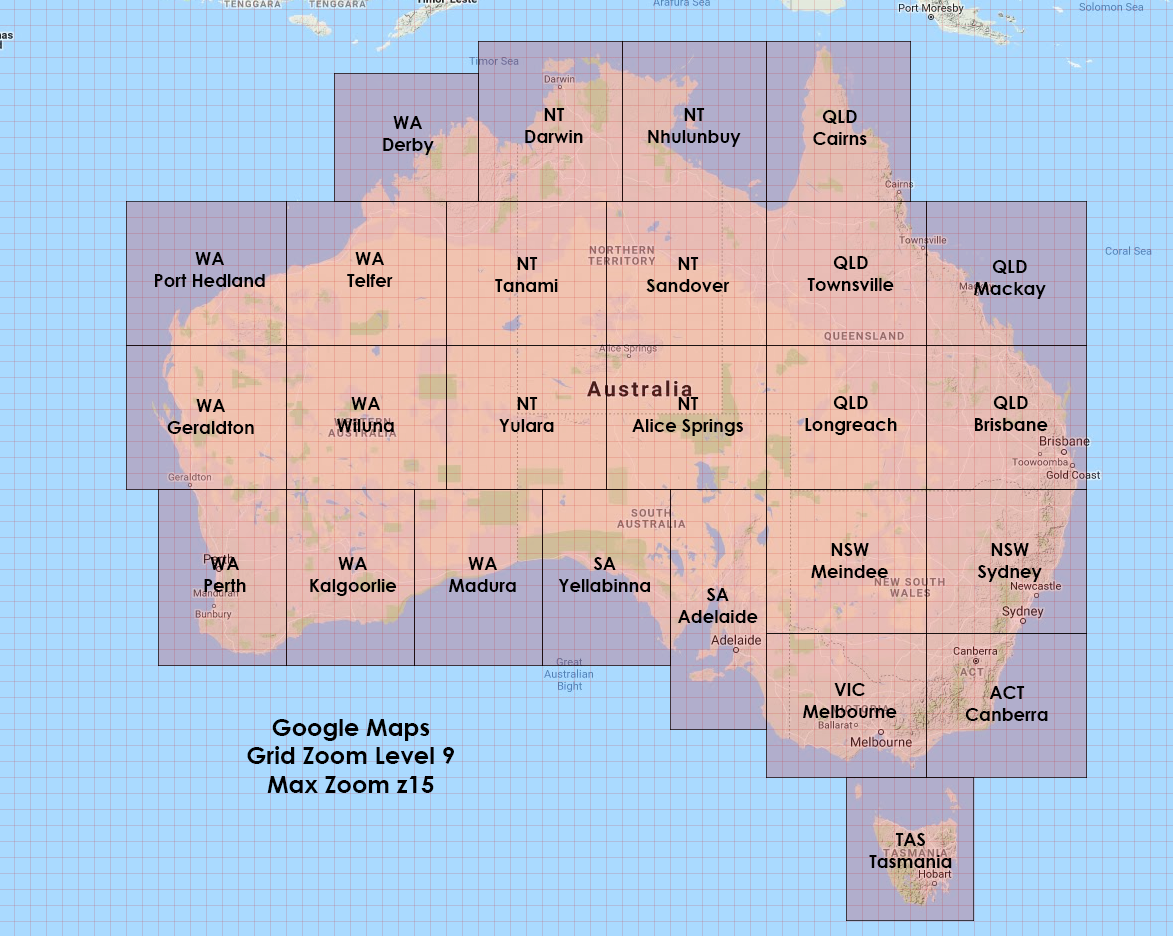
1) Offline areas that you downloaded on your phone or tablet need to be updated at least every 30 days. This is the primary reason why using downloaded Google Maps won’t work in an extended disaster, although it “should” work fine to find your way home in the early stages of a disaster. There is no way to extend or disable this timeframe as per the link below so as soon as you hit that 30 day limit, you lose access to everything.

Can You Stop Google Downloaded Maps Expiring?

2) You don’t have precise control over the resolution or region of the map you want to download. It’s really up to Google to determine how much data is downloaded and what zoom level it goes to. Additionally the downloaded maps are often more focused on the road and includes features for navigating by car and often leaves out a lot of other functionality.

3) Downloading offline areas isn’t available in some regions because of contractual limitations, language support, address formats, or other reasons. Depending on where you are, you may not be able to download your regional maps at all.

4) It’s not easy to export your placemarks, and the more you invest in Google’s ecosystem the more trapped you become in it. For many reasons, I would advise against giving ANY kind of information to a major tech company, and by using Google Maps you are earning them revenue one way or another.

If you would like to download some Google Maps anyway, have a look at the links below:
Android – Downloading Maps with Google Maps (How To)
Apple – Downloading Maps with Google Maps (How To)

Types of maps
There are a lot of different kinds of maps you can download which each have their benefits and specific uses. I will go into more detail about each type below so you can choose which one will best suit your requirements. I’m guessing you’re looking to download a map of your local area for your bug-out route or to have the local terrain on hand for emergency navigation purposes. In this case I recommend a few ‘Road Maps’ and some ‘Topographic Maps’. You may also be looking to keep track of important landmarks or resources in an area such as wild edibles and to use for locating streams and avoiding populated areas. For this I recommend the Satellite Maps primarily and some topographic maps to supplement them.

● All-in-One Map / Road Map
These are shaded, polygonal maps which include all terrain features in detail including roads, parks and structures.

MOBAC bsh Files
Fig1. Google Maps. (All-In-One Map)

E.G. Google Maps
E.G. Bing Maps
E.G. Open Street Map

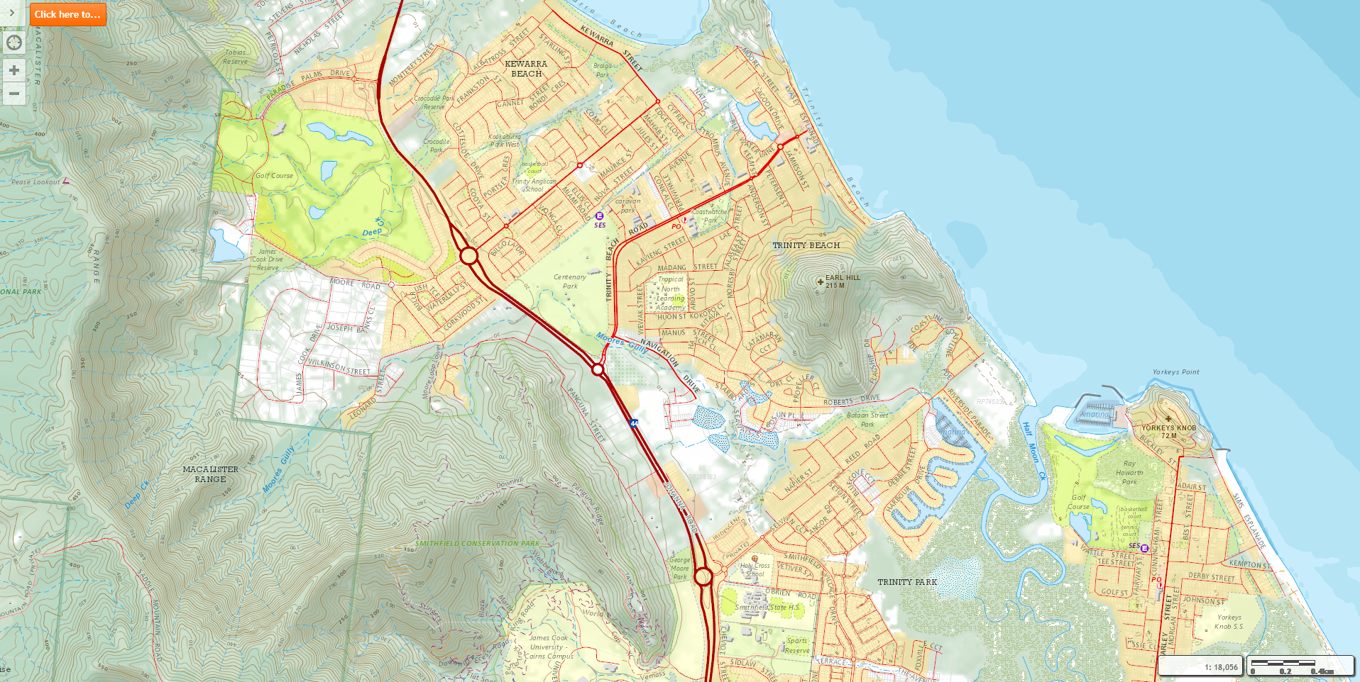
● Topographic Map
Similar to the all-in-one maps but these also include elevation contour lines or shading to show slopes. Generally they have less detail than the All-in-One maps due to not being able to zoom in as much.

MOBAC bsh Files
Fig2. Queensland Topo Map. (Topographic Map)

E.G. Google Maps (Click “Layers” then “Terrain” to enable topo view)
E.G. NGMDB USA Topo
E.G. Australia QLD Topo

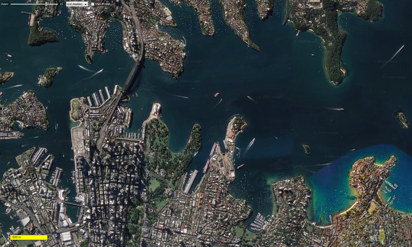
● Satellite Map
These maps show the satellite footage of the area. These are excellent for determining the flora of an area, showing paths, small rivers (which aren’t visible on the above maps) and other useful landmarks. This map isn’t as useful as the Satellite Hybrid map, since there are no labels, however in some circumstances the labels hide important terrain features. I don’t recommend this above the below map unless you have specific reasons to avoid map labels.

MOBAC bsh Files
Fig3. Google Satellite. (Satellite wo/place names)

E.G. Google Maps (Clicking “Layers” should turn on Satellite view automatically, and then hover over “Layers”, click “More” and un-tick “Labels”)
E.G. Bing Maps (Turn on “Satellite” in the menu in the top right and un-tick “Details”.)

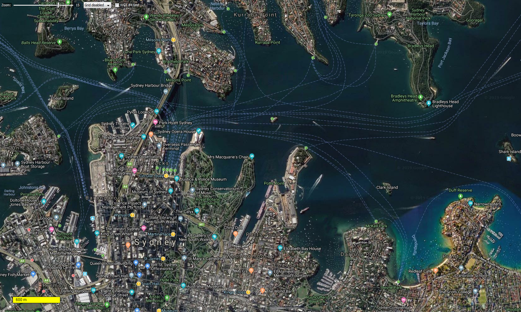
● Satellite Hybrid Map
The satellite hybrid map is the same as the regular satellite map except it includes labels overlaid on top so you can navigate easier.

MOBAC bsh Files
Fig4. Google Satellite Hybrid. (Satellite w/Place Names)

E.G. Google Maps (Clicking “Layers” should turn on Satellite view automatically)
E.G. Bing Maps (Turn on “Satellite” in the menu in the top right)

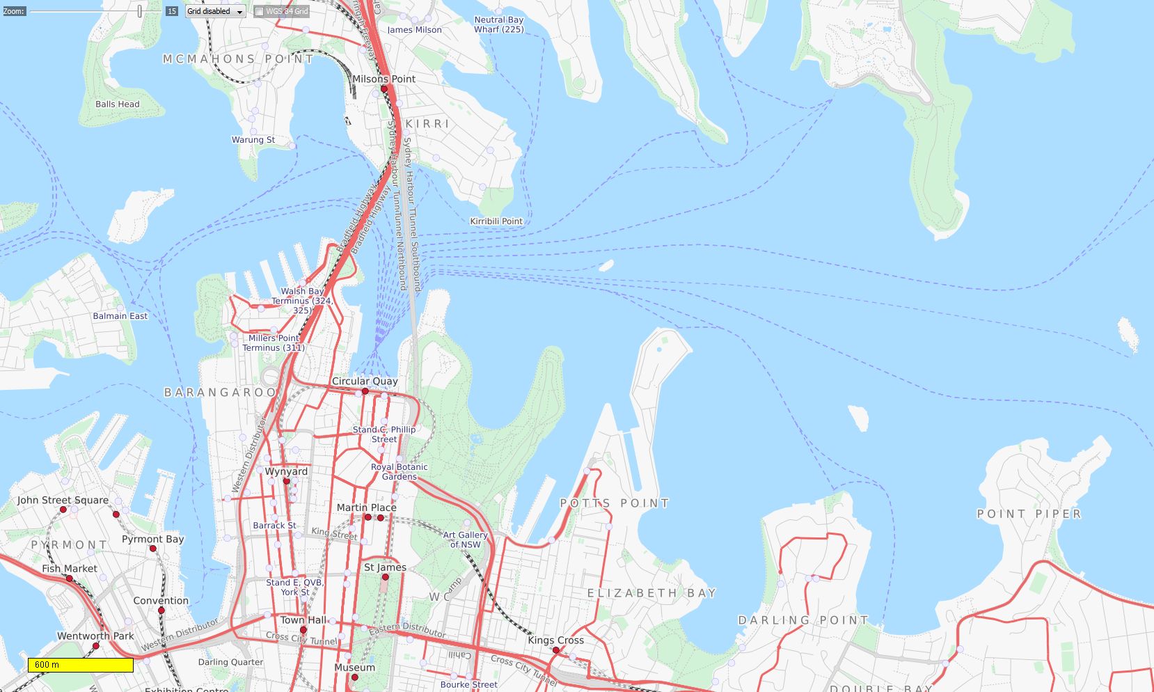
● Other Maps
There are MANY more map types which you may be interested in, including maritime maps, hiking maps, 4WD maps, game maps, population density maps, hunting maps etc, but you can look into these for yourself if you are interested.

MOBAC bsh Files
Fig5. Open Street Map – Transport. (Transport Map)

E.G. Open Street Maps (Turn on the map you want on the right side)
Note: 3D Maps such as Google Earth, cannot be downloaded in 3D.

If you would like more information on the maps above, or you want to download the .bsh files to download them yourself in MOBAC click here. BSH files are the files which populate the “Map Source” list in the top left of MOBAC – so if you’re missing Google maps in the newer versions, you can download it from the link above and put it in the MOBAC “mapsources” folder. (Only works in some versions)

How do I use offline maps?
To get started in offline mapping you will need to work out how the maps will be viewed. My maps are stored on my Android phone and Android tablet on the internal memory. I then use the app “Alpine Quest” to act as the interface to view and manipulate the maps. So work out now what devices you will want to view the maps on, whether that’s a smartphone, a tablet, an e-ink device or even a Garmin navigator. I haven’t used Apple devices before, but all you need for offline maps to work is the ability to copy the downloaded maps to its storage, and of course the app itself which you will be using – so check the App Store for one of the below first.

If you aren’t sure what mapping/navigation program you will be using, here are a few suggestions:
● Alpine Quest – $13 USD (4.6★) (Free Trial Available)
alpinequest.net
“AlpineQuest is the complete solution for all outdoor activities and sports, including hiking, running, trailing, hunting, sailing, geocaching, off-road navigation and much more. You can access and store locally a large range of on-line topographic maps, which will remain available even while being out of cell coverage. AlpineQuest also supports on-board file based maps, like MemoryMap maps.”

An amazing mapping app which can be completely used offline or online if you wish. It’s packed full of every feature you could ever need for navigation, mapping, exploration and prepping. You can purchase a copy directly from Google Play, or from their website above. I use this on all of my Android devices for tracking locations, routes and points of interest.

● OSMAnd – $30 USD (4.6★) (Free Trial Available)
osmand.net
“OsmAnd is a map and navigation app for Android and iOS. It uses the OpenStreetMap map database for its primary displays, but is an independent app not endorsed by the OpenStreetMap Foundation.”
A second piece of mapping software I own. It’s excellent, but I have grown accustomed to Alpine Quest for my primary mapping software.

● BackCountry Navigator TOPO GPS – $15 (3.7★) (Free Trial Available)
backcountrynavigator.com
“Download topographic maps for an offline outdoor navigator! Use your phone or tablet as an off-road topographic mapping handheld GPS! Explore beyond cell coverage for hiking and other recreation. Download topo maps in advance, so you won’t need cell coverage for navigation. Use storage memory for maps.”
I own this one too, but after using it for some time, I just preferred Alpine Quest.

● Orux Maps – $4.49 USD (4.4★)
oruxmaps.com
“Orux Maps is an Online and offline map viewer. You can use different map formats, like GeoPDF from USGS store, GeoTIFF maps, .ozf2, .img garmin (vectorial, no full support is provided), .mbtiles, and others.”

● Garmin Devices
Creating Custom Maps to an Outdoor Handheld Garmin Device
You can create custom maps for some Garmin handheld navigation devices if you already own one, however you may be limited on storage space depending on the model you get – ideally you would want about 20 GB of storage for a good selection of maps.

There are more navigation apps than the ones listed above, but I’m sticking to a few well known ones which are also compatible with MOBAC (Mobile Atlas Creator) – the map creation software, but more on that later. If you want a wider selection, have a look at the compatible list on the MOBAC page. Keep in mind that any maps you download must be in one of the specific formats listed on MOBAC, and these mapping formats cannot (easily) be converted between different apps.

For example if I downloaded a map in the AlpineQuestMap format (AQM), I can only use that map with Alpine Quest and can’t just use it with OSMAnd. (However once MOBAC has successfully downloaded a map in any format such as AQM, and has the downloaded tiles still in memory – you can then export those same tiles into a different format, for example OSMAND without having to download them all again – and the export will only take a minute)

While researching for this blog, I found this software which can apparently convert maps between different formats. It costs, so I would only look into buying it if you are REALLY into mapping.

How much detail do I need?
Downloading maps can become tremendously space intensive if you’re looking to download them in the greatest detail on a wide scale. To put things into perspective, I will go over how many tiles are in the entire planet based on the zoom level (see the chart below). The zoom level is the depth to which a map can be zoomed into which provides more detail. Have you noticed that when you zoom into Google Maps, the last set of tiles disappears and new ones appear of the same region, but in more detail? This is going up a zoom level.

Some maps can be zoomed into 21 times which gives you extreme quality of information, but at the cost of using a lot more space. Other maps can only be zoomed into level 15 to provide a decent amount of detail but it may be hard to distinguish different buildings at that scale. The detail you want in a map is bound by limits on the the upper and lower bounds of the map (yes, some maps only start at a lower zoom level such as 4, which means you have to zoom in a bit before anything appears on the map).

Some maps only go to zoom level 15 – such as the Google Terrain map, so that will be your hard limit when deciding how deep to go, however you will be able to cover a wider area easier due to there being less tiles. Keep in mind that for every tile on a level, four tiles replace it on the zoom level lower than it – this is why the scale below id multiplied by 4 every level you go down.

Below is a chart of the number of tiles in the entire world at a particular zoom level:

Zoom Total Worldwide Tiles Map Scale
z0 1 1:1,183,315,101
z1 4 1:591,657,550
z2 16 1:295,828,775
z3 64 1:147,914,387
z4 256 1:73,957,193
z5 1,024 1:36,978,596
z6 4,096 1:18,489,298
z7 16,384 1:9,244,649
z8 65,536 1:4,622,324
z9 262,144 1:2,311,162
z10 1,048,576 (million) 1:1,155,581
z11 4,194,304 1:577,790
z12 16,777,216 1:288,895
z13 67,108,864 1:144,447
z14 268,435,456 1:72,223
z15 1,073,741,824 (billion) 1:36,111
z16 4,294,967,296 1:18,055
z17 17,179,869,184 1:9,027
z18 68,719,476,736 1:4,513
z19 274,877,906,944 1:2,256
z20 1,099,511,627,776 (trillion) 1:1,128
z21 4,398,046,511,104 1:564

The hard limit to MOBAC’s total downloadable tile count is 500,000, so according to the chart above, if you wanted to download the entire world, you can only download it at z9 as this is closest value lower than the 500k maximum.

For my Google Maps archive, I chose to go with zoom 18 since it’s the first level where you can see the individual house numbers. I have included the other values I went with below to assist in your decision if you get stuck:
● Google Maps (Select Regions) – Zoom Level 18 (I can see the house numbers at this level)
● Google Terrain (Australia-Wide) – Zoom Level 15 (Good enough to hike with and see the terrain, also the maximum zoom)
● Microsoft Hybrid Satellite (Select Regions) – Zoom Level 17 (Good detail to file size ratio)
● Queensland Topographic (Entire State) – Zoom Level 15 (The maximum it zooms to)
● Worldwide Satellite Map – Zoom Level 9 (The maximum allowable limit in MOBAC) (I use this to find cities around the world if needed)

From now on I will refer to the different zoom levels as z then the level. E.G. z18 for Zoom Level 18.

Downloading Maps In-App
Rather than downloading maps via MOBAC (more details in the section below) which is a much more powerful (but complex) way to download maps, I will quickly touch on how you can download maps using the in-app downloaders which can save both time and effort if you want a less complex way to get started.

Most of the apps listed above support in-app downloads which are then stored in the app on the device’s hard drive. Generally these maps must be downloaded every time you swap to a new phone or tablet unless you back them up manually and transfer them every time. However you may find that the stored files cannot be found or copied without rooting your phone.

I’m not able to go over how to download maps in all of the apps above, so I have included links on how to do it for the top two I use:

● Alpine Quest – Downloading a Map
● OSMAnd – Downloading Map Files (You download map ‘packages’ in this app rather than dragging a rectangular region to download)

What do you need to get started downloading with MOBAC?
If you’re still reading then you must be interested in downloading some maps! Below are the physical items you will need to get started:
● An Internet Connection (ideally with 1-4 GB+ worth of data spare per map you want to download)
● A Laptop or Desktop PC running Windows
● A mobile device
● Between $5-$30 depending on which app you want to use (Or you can use the free versions)

What you should know before starting:
● What you want to do with the map?
Do you want to plot and store you bug-out route ready for emergencies? Store important locations for future recall, such as caches and wild edibles? Perhaps you just want it to be a bare map which you can navigate off in an emergency.
● What regions you want to download?
It’s wise to have a couple of very detailed maps (z18) of your immediate area and your bug-out location(s) including frequently traveled routes. Some lower zoom levels (z15) of a wider diameter around your home including all of your bug out routes in their entirety. And finally some very low level zooms (z9) of the entire planet so you can track overseas events if necessary.
● Know the style of map you want to download (Road, Topographic, Satellite, etc)
Remember that there are a huge variety of maps that may interest you and will supplement your bug-out plan in an emergency. I have maps of cell phone tower coverage which can be placed partially transparent over any other map, as well as population density maps which can also go over other maps to show me the danger hot-spots that I should avoid when bugging out.

How do I download a map?
Firstly ensure you know the details of the maps you will be creating:
● What mapping software are you using? (Alpine Quest, OSMAnd, etc)
● What maps do I want to download? (Google Maps, Bing Maps, OpenStreetMaps, etc)

1. On your Windows PC, download the map creation software MOBAC. On the main page scroll down to “Download” and get the latest version. You may want to consider downloading version 1.8 if you want to download any of Google’s maps, as they have been removed in the later versions – however the newer ones have less issues and support a wider range of mapping software file types. Newer versions may require an extra Java installation, but it will let you know on opening whether you need to downloading anything extra or not.

2. Extract & Open MOBAC
This should be pretty self-explanatory but if you have any issues, leave a comment below.
If you don’t have extraction software, you will also need to download Zip Extractor.
(Note: Create a folder and put the .zip file inside it before extracting, or it will make a mess after extraction)

Open the application by double clicking on the “Mobile Atlas Creator.exe” file after extracting the archive in you preferred extractor tool such as WINRAR or Zip Extractor.

MOBAC Application
The Main MOBAC Interface

When you first open MOBAC you are presented with a selection to choose your atlas style, if you don’t know what app you will be using yet you can just choose any for now. When that is closed you will see the map of the world on the right and all your settings for export on the left. (If you are seeing red X’s on the map, try selecting the “OpenStreetMap Public Transport” map in the top left. Try moving around the map by holding the right mouse button and dragging to move the map where you want it. You can scroll to zoom in or out. Note how the map updates with new tiles as you zoom in and out.

These are the different zoom levels being downloaded from the internet and updated on your display in MOBAC. Up the top you will see the zoom level bar which shows you what your current zoom level is. What you see is the live version of the map – nothing is downloaded yet beyond what you request to see on-screen.

Try changing the map style in the top left corner and seeing what different types there are. Some of the maps are only limited to a certain region such as Europe, the USA or Australia. So if you see red X’s after clicking on a map – you are most likely zoomed into a region without coverage, so try zooming out.

3. Change the Map Settings for Download
First select the map source you want to download in the top drop-down, whether that’s ‘Google Maps’ or something else. (Note: Only MOBAC 1.8 or earlier will have the Google Maps options)
Then tick ALL the boxes of the zoom levels that you want to download. If you want to download from z0 to z15, then tick each of them. The selectable zoom levels will change based upon your map selection above, so some will range from z0-z15 and others will go from z0 to z21. If a map only shows up to zoom level 15 then that’s as detailed as that map can get. I recommend selecting from z0 up to and including z18 while you follow along with this tutorial as it will make it easier to understand how everything works.

4. Work out the Map Size
Next set the ‘Grid Zoom’ size at the top of the screen and set it to “12”. This will give you a good range to select the areas you want while getting as close to MOBACs 500,000 maximum tile count as possible. If you don’t select the Grid Zoom level then it’s virtually impossible to have perfectly seamless tiles without downloading duplicate areas since you can drag and select any pixel on the screen. Now drag a rectangle across the map 10×9 squares across the region you want to download.

This is the maximum number of squares you can download within MOBACs limit at this zoom level (z18). You can re-drag and select a shape as many times as you like until you’ve got it right, however you can only draw a single selection rectangle as it will remove your previous one. You can also modify the shape to suit different landmasses which have unique shapes. Some examples of other rectangles you can use are below:

Shape Total Squares Tile Count
30×3 90 491,538
22×4 88 480,640
18×5 90 491,538
15×6 90 491,538
13×7 91 497,001
11×8 88 480,612
10×9 90 491,538
9×9 81 442,391
9×10 90 491,538
8×11 88 480,612
7×13 91 497,001
6×15 90 491,538
5×18 90 491,538
4×22 88 480,640
3×30 90 491,538

So if you wanted to, according to the data above, you could use a bunch of 22W x 4H rectangles to save long strips of a map if you didn’t want to use a more square-ish rectangle such as a 9×10. Keep in mind though that the 22×4 only covers 480,640 tiles, whereas the 9×10 gets a lot closer to the 500k maximum at 491,538 tiles. Therefore it’s more efficient to choose grids that cover more tiles. There is no minimum tile selection, but it’s recommended to select a few tiles to get the hang of how it works, and to save time waiting for the download. Try zooming into your home and selecting a 1×2 or 4×4 grid around it to start with.

Once you’ve made your selection, have a look at the tile count under the “Zoom Levels” menu in MOBAC. If your total tile count is under 500k then you can head on to the next step. If you are over, then you will have to either un-tick your highest zoom level as per the last step OR you can select less tiles to download.

5. Set the map name
If you create enough maps you will need a way to organize each section so you know what region each map covers, what zoom level it is and the date that it was created. To do this I have created a picture showing the coverage of any high zoom maps which I have downloaded.

Australia Map Coverage
Australia Divided into Mapping Regions

Whenever I want to update my maps, I use the corresponding picture as a guide to be sure I select the same regions I have previously so I don’t overlap areas or miss some tiles. It’s highly recommended you do something similar to keep track of your regions. All you really need to do is screenshot MOBAC and use paint to draw rectangles around the zones and then stick a name across it.

My formula for the map title is:
(State/Country) (Location) – (Map Type) (Zoom) (Date)
E.G: Australia QLD Brisbane – Google Maps z18 2024-01

I only really update my maps once or twice per year, so I have just included the year and the month, but if you want to be precise, then you can include the day as well.

6. Add the Map Selection to the Queue
Once you’ve decided on a naming format you can enter this into MOBAC’s “Name” field and click “Add Selection”. Then you can copy the same name, right click the “Unnamed Atlas” field with the purple icon, press “Rename” and paste the name again. The purple sphere where you pasted the second value is generally used for the over-arching type of map, much like a folder which holds lots of a similar files. So if you want, you can specify the region you are downloading multiple files from, such as ‘USA – Tennessee – Google Maps z18’ which could have multiple Tennessee regions in it. You can add as many map selections you want under the purple icon to cover that whole region and they will all download in order, however let’s just start with one for now.

7. Check the Settings
Before starting the download you should click the ‘Settings’ button. Have a browse through each of the settings and change any you want. Some you may want to change is:
● the ‘Unit System’ if you want Imperial measurements,
● the ‘Map Sources’ tab if you want to hide some of the mapping selections on the top left,
● the ‘Tile Update’ tab if you want your tiles to expire earlier,
● the ‘Map Size’ setting which I would set to the biggest size possible (1048575),
● the ‘Directories’ setting if you want to change the output folder and
● the ‘Network’ > ‘Network Connections’ setting to 4, 6, 8 or 10 to download the map a little faster at the risk of getting an IP ban. (An IP ban is when a server blocks your computer for accessing it’s data due to misuse – which is technically what you are doing since downloading SOME maps violates the terms and conditions – for example, Google’s maps. This is why I recommend only increasing it slightly to save a bit of time) (Note: This value is limited to 6 in the newer versions of MOBAC)

Another setting to make note of (but needs no modification at the moment) is the ‘Tile Store’ setting which allows you to see how much space the temporarily stored tiles are occupying. This is fine to delete if you have successfully created a map and aren’t planning on using the tile data again to create another mapping format of the same region.

8. Create the Atlas
Once you’ve changed all the settings you want, then you can create the map!
First ensure that you have the correct profile selected for the mapping software you are using under ‘Atlas Settings’, so “AlpineQuestMap (AQM)” for Alpine Quest.

Then hit that ‘Create Atlas’ button and let it do its thing. (I recommend doing a very small test first to get used to how MOBAC downloads. My suggestion would be to do a single tile or two exactly above your location)

The download can take up to a few hours depending on how big your selection is, but you can watch the progress with the bar. (Note: The progress bar is glitched on the earlier versions of MOBAC, so 66% is technically 100% complete)

MOBAC Download Errors
Occasionally if you have a dodgy internet connection you will see (and hear – in the form of ‘ping error sounds’) that there are tile download errors. Don’t worry about these until the end.

If you get enough errors on a single map download, it will pause the download and ask you if you want to continue to try and download the map. This is a good opportunity to check your internet connection and clicking continue.

Once you reach the end of the download, you will have a complete map which is ready to transfer to your device to test out. If you received more then about 10 tile errors then I recommend deleting that map from the hard drive and clicking ‘Create Atlas’ again. MOBAC will skip all the tiles which were successfully downloaded and only download the missing or expired ones. You can repeat this as many times as you wish until you have no (or very few) tile download failures.

9. Transfer to Device
Once you have a map file, all you need to do now is transfer it to your device and point the application to where your maps are stored. Most of the time you will have to give it access to your device’s storage before it becomes visible, but it will usually ask you for this permission automatically.

10. Play with it!
That’s all you need to do to have offline maps. Once the maps are loaded then you can play with the app to figure out what it can do and how you can use those maps. Try to plot your bug-out route on it and save a few important landmarks that will help you on your journey, such at the closest water sources, hazards and wild food..

How can I keep the MOBAC maps updated?
In step 7 of the process above you would have had a look at the Settings menu and might have seen the ‘Tile Update’ tab up the top. This is where you can set the expiry data on the tiles that are downloaded if no data has been supplied from the website during download. Simply set the expiry time you want, and then follow the steps above and MOBAC will automatically check whether each tile is up to date, and re-download it if it’s not. This is the easiest way to update your stored map tiles and will generally save quite a bit of data. However this comes at the cost of having to store ALL of the downloaded tiles on your PC which can easily chew up a lot of space.

If you choose to delete the tile data between downloads you will just have to download all of the tiles again from scratch, but this isn’t an issue especially if you only update your maps every year since they would have all expired by then anyway.

Closing Remarks
Well that’s about it, I hope this blog has been informative for you and that you’re now one step closer to being more prepared. If you found it useful, please share it with anyone who would benefit from it. If you’re stuck on something, ask a question in the comments below or send me an email, found on the Contact page.

If you enjoyed this blog and would like more information on mapping and digital preparedness, I have included a few similar topics below:
MOBAC Map .bsh Files
Bug-Out Maps
Internet Fallback
Preparedness Map Icons
Reclaim your Passwords!
The Best Preparedness Apps to Download

Upcoming posts include:
● De-Googling a Mobile Phone
● Rooting a Mobile Device

Stay Prepared and God Bless,
Fluidic Ice

Electrical Gauge Specifications and Conversion Table

Lately I’ve been working on a backup lithium power station for those situations when the grid power goes out. You might (or might not – if you watch mainstream media) have heard that many countries have been having great difficulty with their power generation lately and have been losing power multiple times in a day – or have even been without it for a string of days in a row. This is precisely the situation I want to avoid by building my own power station because if you rely of third parties for your essentials such as power, water and gas you are at the mercy of the controlling authorities and utility companies.

Throughout the process of building my own Power Station to power the house I needed a lot of different cable specifications and ratings to be able to ensure it would perform correctly. These include: Cable Gauge (AWG, B&S, mm2) Cable Area (mm2, CM, MCM), Maximum Current, Maximum Surge Current, Maximum Continual Wattage, Cable Diameters with and without insulation, Heat Shrink Sizes, Wire Stripping Guide, Cable Resistance, Cable Weight, Crimping Tool Recommendations and Bootlace Ferrules. It includes both Metric and Imperial measurements for those that need it including conversions between Celsius and Fahrenheit.

Below is the electrical diagram I designed to help me with this project, since I couldn’t find all the information I needed on one website. The image is designed to be printed, laminated and hung as a quick reference guide while working on electrical projects.

Electrical Gauge Specifications and Conversion Table

All the information in the table above has been checked to the best of my ability multiple times over to ensure they are correct, however there still may be errors so do your own research as well as I’m not an electrician.

If you find any errors let me know in the comments below.

Internet Fallback

It’s a strange coincidence that the World Economic Forum simulated a worldwide pandemic a year before one spread across the globe. Strange enough that when they say they will be running a simulated hack of the worldwide internet infrastructure it makes one sit up and pay attention to what’s going to befall the planet next…

For a while now I’ve been quite content where I sit preparedness-wise, so I thought the next logical step to living a ‘normal’ life in a collapse would be to set up an internet fallback. It’s nothing spectacular – just a collection of information I’m likely to research and resources I would draw upon if the internet were to go down.

This includes:
● An offline version of Wikipedia
● Downloaded manuals for ALL my complex devices such as phones, cars, watches, bikes, CB Radios, inverters, headlamps, solar regulators, generators etc
● Mirrored preparedness websites (happypreppers.com, theprepared.com)
● Downloaded preparedness videos from YouTube including medical information, BOB tips, survival tips etc.
● Recent offline maps of my local area (Using MOBAC and run on Alpine Quest)
● Phone applications on a MicroSD card which I can reinstall if I have to wipe it completely
● Ebooks on almost every conceivable topic
● Entertainment such as movies, tv, music and computer games

My emphasis in this post is the downloaded manuals – something which many people forget they will need in an emergency or internet-less situation. It will not only help you use your items to their full potential but may also assist in repairing them if they do happen to break.

Stay Prepared,
Fluidic Ice

Reclaim your Passwords!

With the rise of cancel culture in recent months I’ve been seeking new ways to leave the big tech companies and get back to controlling my own data just in case they ban or delete my accounts. If you aren’t familiar with cancel culture, simply put, it’s when a company or series of companies purges your profile, videos and data from their platform because they disagree with something you say or do. An example of this is Parler when Amazon pulled its servers from under them.

This is a terrifying accumulation of power which we as customers have given them over the years due to simplicity, convenience and the discounts they provide us. Because of this I’m transferring this power back into my own hands by moving my services to smaller companies bit by bit since it would be a challenge to do all at once.

What bothers me most of all is that companies such as Google are actively trying to accumulate as much power over you as they possibly can. One argument I recently thought of in support of this is your passwords. How many of you know the passwords to your online accounts? Do you actively try to create a password which is complex enough but memorable, or do you utilize Google’s automated password generator?

This process works a treat if you’re in-step with Google’s (leftist) policies, but what if you weren’t? What if Google decides to block every one of your accounts including your stored passwords for every website you’ve ever visited? Will you be able to log back in to them and change your password? I doubt it would be easy. It would be virtually impossible if your backup email IS gmail which would now be blocked.

I’ve recently found Ctemplar (2024 update – Ctemplar has ceased operation so I have diversified into Protonmail and Tutamail), an encrypted email service which – most importantly – is a small company with a dedication for user privacy. I’ve started transitioning all my email accounts to Ctemplar over the past few weeks and it’s been going well. I’ve also lined up alternatives to Google Drive, Google Calendar, Google Search and have been creating memorable passwords and writing them down. Sure that’s not best ‘industry practice’ but who would break into your house for a book when there’s a TV and computer right next to it?

Don’t get me started on the amount of personal information these massive corporations are skimming from us and creating a profile online about literally everything you’ve ever done… But I will leave that one for another time.

Reclaim your passwords today and avoid the cyclone of cancel culture that’s coming towards us rapidly!

Current UHF CB Band Plan (80 Channels)

This is the current UHF frequency usage chart if you’re looking for a free channel or just don’t know what each channel is for. CB radios can be a lifesaver if the mobile and internet networks go down and are therefore an invaluable resource to preppers. On flat ground the signal can reach around 5kms (3.1 mi) using about 5 watts of transmitting power.

General chat channels are used in simplex mode, repeater channels must be used in duplex mode.
If you are not using a repeater, it is recommended to choose a “general chat” channel.

Channel Purpose Frequency
1 Repeater Channel – Transmitted from Channel 31 476.4250
2 Repeater Channel – Transmitted from Channel 32 476.4500
3 Repeater Channel – Transmitted from Channel 33 476.4750
4 Repeater Channel – Transmitted from Channel 34 476.5000
5 Emergency Repeater Output – Transmitted from Channel 35 476.5250
6 Repeater Channel – Transmitted from Channel 36 476.5500
7 Repeater Channel – Transmitted from Channel 37 476.5750
8 Repeater Channel – Transmitted from Channel 38 476.6000
9 General Chat Channel 476.6250
10 4WD Clubs or Convoys and National Parks 476.6250
11 Call Establishment Channel 476.7000
12 General Chat Channel 476.7000
13 General Chat Channel 476.7250
14 General Chat Channel 476.7500
15 General Chat Channel 476.7750
16 General Chat Channel 476.8000
17 General Chat Channel 476.8250
18 Caravanners and Campers Convoy Channel 476.8500
19 General Chat Channel 476.8750
20 General Chat Channel 476.9000
21 General Chat Channel 476.9250
22 Telemetry and Telecommand Only (No Voice or Data) 476.9500
23 Telemetry and Telecommand Only (No Voice or Data) 476.9750
24 General Chat Channel 477.0000
25 General Chat Channel 477.0250
26 General Chat Channel 477.0500
27 General Chat Channel 477.0750
28 General Chat Channel 477.1000
29 Road Safety Channel (Pacific Hwy between Brisbane and Sydney) 477.1250
30 General Chat Channel 477.1500
31 Repeater Input – Broadcaststo Channel 1 (w/Duplex Enabled) 477.1750
32 Repeater Input – Broadcaststo Channel 2 (w/Duplex Enabled) 477.2000
33 Repeater Input – Broadcaststo Channel 3 (w/Duplex Enabled) 477.2250
34 Repeater Input – Broadcaststo Channel 4 (w/Duplex Enabled) 477.2500
35 Emergency Repeater Input – Broadcasts to Channel 5 (w/Duplex Enabled) 477.2750
36 Repeater Input – Broadcaststo Channel 6 (w/Duplex Enabled) 477.3000
37 Repeater Input – Broadcaststo Channel 7 (w/Duplex Enabled) 477.3250
38 Repeater Input – Broadcaststo Channel 8 (w/Duplex Enabled) 477.3500
39 General Chat Channel 477.3750
40 Road Safety Channel Australia Wide 477.4000
41 Repeater Channel – Transmitted from Channel 71 476.4375
42 Repeater Channel – Transmitted from Channel 72 476.4625
43 Repeater Channel – Transmitted from Channel 73 476.4875
44 Repeater Channel – Transmitted from Channel 74 476.5125
45 Repeater Channel – Transmitted from Channel 75 476.5375
46 Repeater Channel – Transmitted from Channel 76 476.5625
47 Repeater Channel – Transmitted from Channel 77 476.5875
48 Repeater Channel – Transmitted from Channel 78 476.6125
49 General Chat Channel 476.6375
50 General Chat Channel 476.6625
51 General Chat Channel 476.6875
52 General Chat Channel 476.7125
53 General Chat Channel 476.7375
54 General Chat Channel 476.7625
55 General Chat Channel 476.7875
56 General Chat Channel 476.8125
57 General Chat Channel 476.8375
58 General Chat Channel 476.8625
59 General Chat Channel 476.8875
60 General Chat Channel 476.9125
61 Reserved for Future Expansion
62 Reserved for Future Expansion
63 Reserved for Future Expansion
64 General Chat Channel 477.0125
65 General Chat Channel 477.0375
66 General Chat Channel 477.0625
67 General Chat Channel 477.0875
68 General Chat Channel 477.1125
69 General Chat Channel 477.1375
70 General Chat Channel 477.1625
71 Repeater Input – Broadcasts to Channel 41 (w/Duplex Enabled) 477.1875
72 Repeater Input – Broadcasts to Channel 42 (w/Duplex Enabled) 477.2125
73 Repeater Input – Broadcasts to Channel 43 (w/Duplex Enabled) 477.2375
74 Repeater Input – Broadcasts to Channel 44 (w/Duplex Enabled) 477.2625
75 Repeater Input – Broadcasts to Channel 45 (w/Duplex Enabled) 477.2875
76 Repeater Input – Broadcasts to Channel 46 (w/Duplex Enabled) 477.3125
77 Repeater Input – Broadcasts to Channel 47 (w/Duplex Enabled) 477.3375
78 Repeater Input – Broadcasts to Channel 48 (w/Duplex Enabled) 477.3625
79 General Chat Channel 477.3875
80 General Chat Channel 477.4125

Preparedness Bags

This is an excerpt from my PDF ‘The Preparedness Encyclopedia (TPE)’.
Download the PDF Version Here

Backpacks are an essential resource in the prepping community, they are designed to carry your gear and take the weight of them off your back. There are multiple types of prepping backpacks each with a unique purpose, and even though you don’t need them all, they have their place in your life. Generally they are designed to hike out into the mountains with and be fairly lightweight however every person is different and so should their bag. Having a lightweight pack means you can travel further and faster allowing you to GOOD faster if SHTF.

For the recommended contents of this kits, see the GEAR section in TPE.

Pocket Survival Kit (PSK)
The Pocket Survival Kit is a small tin which can fit into any pocket with the basics for survival.

● Size: The pocket survival kit should be small enough to fit into a pocket. A recommended size would be the size of an ‘Altoids’ tin or approximately 2.36″ (6cm) x 3.75″(9.5cm) x 0.7″ (2cm) High.
● Weight: Your PSK kit should be extremely lightweight and inconspicuous, typically below 150 grams.

Every Day Carry (EDC)
Stands for Every Day Carry – The kit you take with you everywhere you go and generally stays on your body or sometimes in the car.

● Size: Your EDC kit should all fit inside a moderate sized organising cell approximately 12cm (4.7″) x 12cm (4.7″) x 4cm (1.5″). But keep in mind that not all of it will be stored in this case, but instead on your body.
● Weight: Your EDC kit should be very lightweight and inconspicuous, typically below 500 grams (1.1 lbs).
This pack isn’t limited to a bag but also includes clothes, wearables such as watches and a gun. The 5 C’s of survival which the EDC kit generally should cover is: Cutting, Cordage, Combustion, Cover and Container.

Get Home Bag (GHB)
The Get Home Bag is only used for returning home to your preps and bug-out bag in a disaster such as EMP and there’s no transport.

● Size: A GHB should be the size of a small backpack. This can be between a 10L and 20L backpack. (2.1 – 4.2 gal). Size and fit should be based off the person’s size.
● Weight: The GH bag should be a lightweight pack under 3kgs (6.6 lbs) which doesn’t draw attention to yourself.
The bag is designed to get you home within 24 hours and can only sustain you for this period – including overnight once. It is assumed that you won’t have access to any reasonable food or clean water along the way home thus bringing your own is essential.

Bug Out Bag (BOB)
Stands for Bug-Out-Bag – The bag you take when SHTF and it’s purpose is to only assist you to reach a BOL within 3 days.

● Size: Your Bug Out Bag’s size should be between 30L and 80L. (6.5 – 17.5 gal) Size and fit should be based off the person’s size.
● Weight: Your BOB should weigh at most 1/5th of your weight. For ultralight the weight should be below 5kgs (11 lbs) or 1/15th of your weight.
These bags are typically designed to be carried on foot however – hiking frames, bikes and cars are also useful ways to transport your gear.

I’m Never Coming Home Bag (INCH)
Stands for I’m Never Coming Home – The bag you take when you aren’t “ever” returning home. Of course one day you might return, but the point is that when you return you expect your house to be destroyed and the contents gone. Therefore it should also contain everything you don’t wish to lose.

● Size: Your INCH bag should be between 50L and 120L. (11 – 26.3 gal) Size and fit should be based off the person’s size.
● Weight: Your INCH bag should weigh at most 1/4th of your weight, assuming you’re carrying it yourself.
Typically INCH bags are accompanied with a transport mode such as a car or a bicycle as they can weigh up to 100kg’s. The bag includes more tools then all other bags which are single function to increase their longevity and efficiency. The bag only has 7 days worth of food and water for one person – therefore acquiring an income of food and water is vital early on.

Survival Comfort And Redundancies (SCAR)
The Survival Comfort And Redundancy (SCAR) bag is a term I coined in response to all the spare prepper gear I accumulated that wouldn’t make it into any of my other bags. Its primary purpose is to store your spare and redundant supplies to increase your comfort and give you more redundancies during bugging out. It should be grabbed in addition to your other bags if you have the space available in your car. However if it’s not required later on, or you can’t carry it any more you can safely ditch it knowing that you already have the basic gear in your BOB/INCH bags.

● Size: Your SCAR bag could be between 10L and 150L. (2.1 – 33 gal) Any bigger than 150L (33 gal) then this bag may be a struggle to carry depending on what’s inside. This bag doesn’t have to be a backpack, but could also be a duffel bag or other type of bag.
● Weight: Weight shouldn’t matter in a SCAR bag as it will only be used if you are using vehicle transport and have free space. However an average estimate would be 5-30kgs (11 – 66 lbs).
This bag could contain things like extra warm clothing and blankets, tool redundancies like hatchets, knives and shovels, extra camping gas, fishing snares and larger traps, long rolls of paracord or advanced medical equipment. Most preppers have spare items that didn’t make it into their BOB’s so why not have them in a bag themselves to grab if the need arises and you have the space available.

Zero Hour

This is an excerpt from my PDF ‘The Preparedness Encyclopedia (TPE)’.
Download the PDF Version Here

Zero Hour signifies an unknown date and time that a disaster worthy of preparedness action occurs. You could be anywhere when ‘zero hour’ occurs and your primary objective from then on is to reach your preps and then decide how you should proceed. An example of zero hour is the second you hear about a nuclear exchange in your country.

● Bug In or Out
When an incident occurs weigh the benefits of bugging in and out and whether it will get harder to travel as time progresses or not.

● Be Ready
When the situation arises to bug out, you should be ready to grab the bags and go with enough food you will need to survive the disaster.

● Be Aware
You want to be one of the first people to realize the gravity of the disaster and leave long before anyone else considers it or the roads will be parking lots.

Contact
When you first hear about a disaster that is or will affect you, the immediate action taken would be to contact your family and others whom you will meet up with. Whoever hears about the disaster first and contacts the others in the party, will give the others more time to prepare to leave work or meet up at the rendezvous point earlier. Confirm the plans you have with everyone on the phone and where they are currently as they may need assistance getting to the rendezvous point. If your family is at home already get them to start packing the car and be ready when the last person shows up. If no communications is available such as during an EMP you should follow through with the plan you set up prior to the event.

Returning Home
If you’re away from your preps the first thing you’ll want to do is return to a rendezvous point where your companions or family will meet up. You may not have an available mode of transport for returning home therefore you may have to walk home.

Step 1 Communicate
Communicate with your family or bug out partners if possible and tell them what’s happening and to set in motion one of the plans based on the scenario. Try to use code such as: Location X or Location Delta as there’s always the chance that people are listening in or some who will ambush you there. Include what to do if communications are down such as returning home and packing the car ready.

Possibilities
● Communication Works
● Communications Down
● Everyone Together

Communication Points
● Communication Works
● Communications Down
● Everyone Together

Step 2 Rendezvous Point
The location you will meet if a disaster occurs. It should include an estimated timeframe of when you should expect to meet after a disaster occurs if communications are down.

Step 3 Gear Grab
Your gear is basically essential to grab before you bug out. The only reason you wouldn’t is if it’s already packed, you can’t safely reach it or you are more likely to die trying to retrieve it. You should have your gear pre-packed in a secure, easily accessible location so you can grab it as quickly as possible.

Step 4 Depart
Set out on your selected bug-out route with your party members. If you forget anything after you leave you shouldn’t return for it unless it’s essential to your survival.